Flight Delays and Airport Impacts: March 12
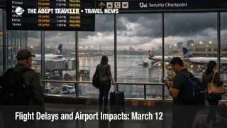
The Federal Aviation Administration said on Thursday, March 12, 2026, that low clouds may slow flights in Boston Logan International Airport (BOS) and Seattle Tacoma International Airport (SEA), thunderstorms could delay traffic in Newark Liberty International Airport (EWR), John F. Kennedy International Airport (JFK), LaGuardia Airport (LGA), Philadelphia International Airport (PHL), and Hartsfield Jackson Atlanta International Airport (ATL), and high winds are forecast in Dallas Love Field Airport (DAL) and Dallas Fort Worth International Airport (DFW). For travelers, that sets up a Northeast and East Coast corridor problem first, with North Texas and selected downstream connections also exposed later in the day. The practical move is to protect layover time, avoid cutting airport arrival times too close, and treat afternoon connections through New York and Philadelphia as the weakest links.
Flight Delays and Airport Impacts March 12 are being driven by overlapping weather and flow management pressure, not one isolated airport failure, which means problems can spread from the Northeast into Florida, Mid Atlantic, and connection banks elsewhere even when your first flight looks normal on the app.
Flight Delays and Airport Impacts March 12: What Changed
The biggest change from Flight Delays and Airport Impacts: March 11 is that March 12 shifts the main stress east, with the FAA's daily report centering on New York, Philadelphia, Boston, Seattle, Atlanta, and North Texas instead of yesterday's broader Midwest and interior storm pattern. The FAA Command Center's operations plan goes further than the public daily summary by saying Philadelphia is under a probable ground stop or delay program until midnight because an equipment outage has forced a single Runway 27R operation. It also flags possible ground stops or delay programs later in the day for Palm Beach International Airport (PBI), Ronald Reagan Washington National Airport (DCA), Newark, LaGuardia, JFK, Denver International Airport (DEN), Orlando International Airport (MCO), and Tampa International Airport (TPA).
That matters because once Philadelphia and the New York airports are both constrained, the network loses one of its main recovery cushions for East Coast banks. Even travelers not touching those airports directly can get caught by late inbound aircraft, tighter gate turns, and missed onward connections.
Which Travelers Face the Most Disruption Today
The most exposed travelers are people connecting through New York area airports this afternoon and evening, travelers using Philadelphia as a domestic or transatlantic bridge, and anyone trying to flow between the Northeast and Florida on a tight schedule. The FAA says thunderstorms are affecting multiple air traffic centers, active flow programs are already in place for Florida related routes, and high seasonal snowbird volume is adding pressure to the same broad corridor.
This is also a bad setup for spring break style itineraries with little slack. Travelers who booked short connections, same day cruises, nonrefundable tours, or late hotel arrivals at destination are carrying more risk than the raw airport list suggests, because delay propagation usually hits those timed downstream commitments before it shows up as a dramatic cancellation headline. That is the same broader capacity problem Adept Traveler flagged earlier in United Spring Break Forecast Raises Airport Stress, and March 12's corridor based FAA plan fits that pattern.
What Travelers Should Do Before Leaving for the Airport
Travelers flying through Newark, JFK, LaGuardia, Philadelphia, Washington National, Orlando, Tampa, or Denver should build more buffer than usual today, especially for departures after midday. If you have a connection under about 90 minutes through the New York area or Philadelphia, the smart move is to look for earlier alternatives before the day fully compresses.
If your trip depends on a same day handoff, a cruise embarkation, a business meeting, or a prepaid timed entry, today is the kind of day to reprice the cost of arriving late versus the cost of switching early. Waiting can still make sense for nonstop flying out of a lightly affected origin, but it makes less sense when your itinerary depends on an East Coast connection bank that may be metered later.
Over the next 24 to 72 hours, watch for whether this stays a one day weather and equipment event or whether carriers start carrying delay residue into Friday morning aircraft rotations. The FAA's morning report is only a planning snapshot, and days like this often worsen after the first round of traffic management initiatives starts stacking across the Northeast and Florida bound system.
Why the Delays Are Concentrating in the Northeast
Low clouds and thunderstorms matter because they reduce how many aircraft an airport can safely accept and depart in a given period. When that happens at one big hub, airlines can often absorb some of the pain. When it happens across several linked airports at once, traffic managers start spacing flights farther apart, rerouting flows, or holding departures at origin, which is why a weather day can turn into a national timing problem without becoming a national shutdown.
Philadelphia's extra problem is different. The FAA says a probable ground stop or delay program there is linked to an equipment outage that has resulted in a single runway operation. In plain language, that means the airport is not just dealing with weather, it is also operating with less flexibility, which makes recovery harder if storms or arrival surges hit at the same time. Add active Florida route programs, thunderstorm constraints across multiple air traffic centers, and possible Gulf and Atlantic routing restrictions, and the mechanism becomes clear, small delays in one corridor can quickly become missed connections and late arrivals far beyond the airport where they started.