Flight Delays and Airport Impacts: April 20
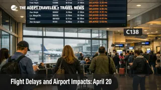
April 20 flight delays are shaping up as a weather driven hub problem, not a single airport event. The Federal Aviation Administration said on Monday, April 20, 2026 that wind and low clouds may delay flights in Boston Logan International Airport (BOS) and across the New York system at Newark Liberty International Airport (EWR), John F. Kennedy International Airport (JFK), and LaGuardia Airport (LGA), while thunderstorms could slow South Florida traffic at Fort Lauderdale Hollywood International Airport (FLL) and Miami International Airport (MIA). Low clouds are also in the mix for Los Angeles International Airport (LAX) and San Diego International Airport (SAN), and the FAA's operations plan says San Francisco International Airport (SFO) could move into stronger control programs later in the day. Travelers with short layovers, late bank connections, or same day onward rail and cruise links should build buffer now rather than waiting for formal ground stops to stack up.
April 20 Flight Delays: What Changed
The most important shift on April 20 is that the FAA is not describing isolated local friction. It is flagging a spread of weather constraints across multiple major traffic flows at once, with the Northeast, South Florida, Southern California, the Bay Area, and Washington, D.C. all on the map. In the daily report, the FAA specifically warned of wind and low clouds in Boston and New York, thunderstorms in Fort Lauderdale and Miami, low clouds in Los Angeles and San Diego, and possible wind delays in San Francisco and the Washington area airports of Baltimore Washington International Thurgood Marshall Airport (BWI), Ronald Reagan Washington National Airport (DCA), and Washington Dulles International Airport (IAD).
The operations plan makes the day more concrete. The FAA listed BOS under showers and wind, the New York terminal area under low ceilings and showers, San Francisco under wind, Miami and Fort Lauderdale under thunderstorms, and Los Angeles and San Diego under low ceilings. It also said a ground stop or ground delay program was probable at San Francisco after 300 p.m. PDT, possible at Newark after 400 p.m. PDT, possible at Miami and Fort Lauderdale after 500 p.m. PDT, and possible at JFK after 700 p.m. PDT. That does not guarantee all of those programs will fully materialize, but it does show where the FAA expects the system to tighten first if forecast conditions hold.
Which Travelers Face the Most Risk Today
The most exposed travelers are the ones connecting through the Northeast and South Florida during the afternoon and evening push. New York delays rarely stay local for long because EWR, JFK, and LGA sit inside one of the country's most tightly managed terminal areas. When low ceilings and showers reduce arrival rates there, delays can spread into departures, aircraft rotations, and crew timing far beyond the city itself. That turns a weather problem in one metro area into a wider network reliability problem for itineraries that were already built on tight turn times.
South Florida has a different exposure pattern. Thunderstorms there can hit both local airport operations and the major north south traffic flows feeding the peninsula. The FAA's plan also flagged en route thunderstorm constraints across several air traffic control centers, along with Florida arrival route management later in the day. That means travelers flying into Miami, Fort Lauderdale, Orlando, Tampa, or Southwest Florida later today may see pressure build even if their departure airport starts the day in decent shape.
Bay Area travelers should take San Francisco seriously even before a formal program posts. The FAA's plan says southeast wind in San Francisco will likely lead to terminal initiatives, and the airport is already operating with a long construction window on runway and taxiway infrastructure. That combination matters because weather cuts arrival efficiency first, and construction reduces the room the airport has to absorb disruption cleanly. In an earlier Adept Traveler article, Flight Delays and Airport Impacts: April 18, the same broader lesson showed up in a different weather setup, a day does not need a national meltdown to break same day plans once a few big hubs lose slack. Travelers who want the structural version of that problem can also read How Air Travel Disruptions Cause Ripple Effects Across Regions.
What Travelers Should Do Now
The immediate move is simple. Check your airline app early, not just the airport board, and treat connections under about 90 minutes through New York, Boston, Miami, Fort Lauderdale, and San Francisco as exposed if you are traveling later today. If you have a choice between holding a tight connection and shifting to a slightly earlier departure, earlier is the safer trade today because the FAA's risk map leans toward conditions worsening as the day goes on in several key regions.
If you are not yet at the airport and your itinerary runs through one of the most likely control points, the next decision point is whether your trip can tolerate a late arrival. If the answer is no, because of a cruise embarkation, an international connection, a timed event, or a nonrefundable same day hotel move, rebooking into more margin is stronger than waiting for the official delay program to hit. Once ground stops and GDPs post, the remaining seats and same day alternatives usually get worse, not better. The FAA itself says travelers should always check with their air carrier for flight specific delay information.
Travelers already committed to flying today should monitor a narrow set of signals over the next several hours. Watch for San Francisco action after mid afternoon Pacific time, Newark after late afternoon Eastern time, Miami and Fort Lauderdale in the early evening, and JFK by early evening if New York weather remains constrained. If those programs appear in sequence, April 20 flight delays could turn from manageable local slowdowns into a wider evening recovery problem.
How April 20 Flight Delays Could Spread Later
The mechanism behind April 20 is straightforward. Weather reduces the number of arrivals an airport or terminal area can safely handle, then traffic management meters flights into that constraint. Once that happens at hubs like New York or San Francisco, the first order effect is longer arrival and departure delay. The second order effect is broader network damage, late inbound aircraft, crews timing out, misconnects at hubs, thinner rebooking inventory, and longer lines at customer service desks far from the original weather.
There is also a reason this can feel worse in the late day banks than in the morning. Delays accumulate. A modest weather slowdown at one hub can still be absorbed early when crews and aircraft have some slack left. By late afternoon and evening, that slack is mostly gone, and a delay in Newark or San Francisco can start colliding with Florida thunderstorm routing, Washington area wind constraints, and normal end of day crowding. The FAA's April 20 plan reflects exactly that kind of layered risk rather than one single crisis airport.
What happens next depends on whether the forecast windows verify and how long the control programs last once they begin. If conditions improve faster than expected, some airports may stay in minor delay territory. If the New York and Florida pieces deepen at the same time, tonight's recovery could become the real story. For now, the practical takeaway is to manage April 20 flight delays as a protect the itinerary day at major hubs, especially if your plan depends on connections, last minute ground transfers, or a hard arrival deadline.