Northeast Storm Flight Delays Linger December 15, 2025
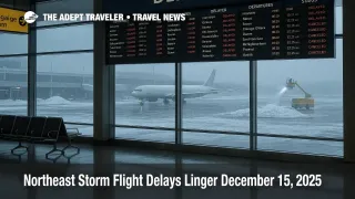
Northeast storm flight delays are lingering across the New York metro area and New England on December 15, 2025, as weekend snow and bitter cold slow airline recovery. Travelers flying through John F. Kennedy International Airport (JFK), LaGuardia Airport (LGA), Newark Liberty International Airport (EWR), Boston Logan International Airport (BOS), and Philadelphia International Airport (PHL) should expect uneven schedules, longer taxi times, and late inbound aircraft. If you have a connection, add buffer, consider moving to a nonstop, and avoid tight last flight itineraries where one slip becomes an overnight.
The northeast storm flight delays story today is less about fresh snowfall at every airport, and more about recovery friction, deicing, aircraft positioning, and air traffic flow controls that can ripple across the day.
Northeast Storm Flight Delays On December 15, 2025
One useful way to size up the disruption is to separate nationwide totals from the slice that actually touches U.S. itineraries. FlightAware's live tracker showed 1,611 delays and 280 cancellations within, into, or out of the United States on December 15, 2025, alongside much larger worldwide totals that can look alarming if you do not filter them. Those numbers are consistent with a recovery day where cancellations do not always spike, but missed turns, gate holds, and deicing queues keep delay counts elevated.
Over the weekend, the same system produced widespread operational strain, including heavy snow in the New York New Jersey area and a sharp cold push behind it, according to the Associated Press. For travelers, that matters because the cold behind a storm can be as disruptive as the storm itself. When ramp temperatures stay low, aircraft need more deicing, and the deiced window is shorter if precipitation lingers or frost reforms.
For New York area airports specifically, Sunday's impacts illustrate why Monday's schedule can stay fragile even if the radar looks quieter. Business Insider reported significant Sunday disruptions at JFK, including long ground delays, large numbers of delayed flights across the metro area, and an FAA ground delay program during snow and ice removal. When aircraft arrive late, or sit waiting for gates, they do not get turned and repositioned on time for the next morning's departures.
Why Recovery Days Break Itineraries
Airline schedules are built on tight connections between aircraft, crews, gates, and runway acceptance rates. In winter weather, two things usually snap first.
The first is aircraft and crew positioning. A cancellation Sunday evening can strand a crew, or leave an aircraft in the wrong city. Monday morning then starts with substitutions, ferry moves, and late starts that hit short haul routes hardest because they turn the most times per day.
The second is surface operations, especially deicing and runway treatment. A National Weather Service decision support briefing for the Philadelphia and Mount Holly region highlighted widespread snowfall totals of 1 to 5 inches with locally more than 5 inches possible along the I 95 corridor, followed by bitter cold impacts, including wind chills in the single digits at night. That combination is exactly what drags out recovery. Snow and slush slow ground crews and vehicle movement, and then the cold locks in frost, refreezing, and longer deicing cycles.
FAA air traffic flow measures can also change quickly as conditions improve or deteriorate. The FAA's current operations plan advisories are where you sometimes see a formal program end even while delays persist locally. Early on December 15, 2025, an FAA advisory indicated that a delay program for JFK had been canceled, signaling some improvement in planned flow constraints. That is helpful, but it does not guarantee a smooth day, because airport level congestion can remain even after a specific program is lifted.
If you want a snapshot by airport, the FAA's airport status pages can show whether a location is reporting broad arrival or departure delays. For example, the FAA status page for LaGuardia showed only minor general delays early Monday, which can happen when conditions briefly stabilize between arrival banks. Treat these pages as a trend indicator, not a promise, because the next wave of inbound flights can quickly tighten gates and taxiways.
What This Means For NYC, Boston, And Philadelphia Travelers
For travelers in and out of the New York metro airports, the biggest risk is not a single delay, it is the chain reaction. A 60 minute delay leaving Charlotte or Chicago can become a missed connection at JFK, then a forced rebook where the next available seat is tomorrow. If you are connecting through the New York area today, the safest move is to reduce your dependence on that connection. That means shifting to a nonstop where possible, or rerouting through a hub outside the affected weather footprint.
For BOS and PHL travelers, the pattern is similar, with an added twist. These airports feed, and receive, a lot of short haul rotations from the New York area. When New York runs behind, the delays propagate outward, even if Boston's local weather is calmer in a given hour. Philadelphia can also see compounding effects when weather and deicing slow turns on the ground while arrivals keep coming.
Lake effect and lingering advisories can keep disruption active in the broader region too. On December 15, 2025, National Weather Service winter weather advisories remained in effect in parts of New York, including lake effect zones, with additional accumulations still possible. Even if you are not flying into those counties, feeder flights and crews often move through the same airspace and aircraft rotations.
If this sounds familiar, it is because it is a repeatable winter pattern. If you want context on how disruption numbers get misread, and why "cancellations" can be the wrong headline on a delay heavy day, see our internal explainer in the Misinformation topic hub: Misinformation. For the storm setup that led into today's recovery, see our prior coverage: Northeast Winter Storm Flight Delays, and the broader national picture from yesterday's operations: Flight Delays And Airport Impacts: December 14, 2025.
Practical Moves That Reduce Risk Today
Travelers who do best on recovery days make one decision early, whether to protect the itinerary, or to ride it out. Protecting the itinerary usually means paying for certainty, choosing a nonstop, taking a later departure, or accepting a longer connection to avoid a misconnect. Riding it out means you are willing to risk a missed connection in exchange for keeping the original routing.
If you have not left for the airport yet, check whether your airline has issued a travel waiver for the affected airports. Waivers can let you move flights without paying a change fee, sometimes even if your ticket is otherwise restrictive. If you do have to travel today, prioritize flights earlier in the day only if your inbound aircraft is already in position and your first leg is not coming from another impacted station. Otherwise, a midday departure can be safer because the system has had time to unwind, and crews have had time to be repositioned.
Finally, build your ground plan as if the terminal is not the only friction point. Cold mornings can bring black ice risk on untreated surfaces, slower curb operations, and longer transit times to the airport, especially after plowing and refreezing cycles. A small buffer on the road can be the difference between making your rebooked flight and spending the night.
Sources
- Weekend storm drops heavy snow around Northeast as Pacific Northwest braces for more rain
- Live Airline Flight Cancellations Info & Statistics
- National Airspace System Status
- Current Operations Plan Advisory
- Accumulating Snow, then Bitter Cold December 14-16, 2025 (NWS Mount Holly briefing PDF)
- WWA Summary for Winter Weather Advisory
- La Guardia Airport (LGA) Real-time Status