Northeast Winter Storm Delays New York Flights Dec 26 27
A winter storm warning window from Friday evening, December 26, 2025, into Saturday, December 27, 2025, is set to disrupt travel across the New York metro area, including air and road transfers. Travelers flying through the region's hub airports and anyone attempting same day airport changes across the city are most exposed. The practical move is to avoid tight connections, favor earlier departures, and build a larger buffer for ground transfers, especially Friday evening.
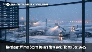
New York winter storm flight delays are likely because heavy snowfall rates, deicing demand, and reduced airport arrival capacity tend to stack up at the same time across the region.
The National Weather Service New York office briefing calls for 5 to 9 inches in the winter storm warning area, with some localized totals above 10 inches possible where banding sets up, and peak snowfall rates around 1 to 2 inches per hour. The same briefing highlights the most impactful timing as roughly 500 p.m. to 1100 p.m. for the NYC metro, northeast New Jersey, and the Lower Hudson Valley, with a later peak for parts of Long Island and southern Connecticut. The warning timing in the briefing runs from about 400 p.m. Friday until about 100 p.m. Saturday for much of the NYC region, which means overnight cleanup and morning recovery still matter for Saturday departures.
For traveler context and earlier storm mechanics, see Northeast Winter Storm Flight Delays Raise Misconnect Risk.
Who Is Affected
Travelers with itineraries to, from, or through John F. Kennedy International Airport (JFK), LaGuardia Airport (LGA), and Newark Liberty International Airport (EWR) are the obvious first tier, but the knock on effects can spread well beyond New York because these airports sit inside a dense, capacity constrained airspace and connect to a large share of transatlantic, domestic hub feed, and holiday peak day leisure flows. Even if your final destination is not New York, an itinerary that relies on a connection through one of these airports, or an inbound aircraft rotation that starts its day in the region, can inherit delays.
Short connections are especially fragile Friday evening and overnight. Snow pushes more aircraft into deicing queues, slows taxi and runway throughput, and forces air traffic control (ATC) flow programs that meter arrivals into the New York area. When arrivals are throttled, aircraft can sit at origin waiting for a departure slot, or they can arrive late and occupy gates longer than planned, which then blocks the next departures in a gate limited terminal. The outcome for travelers is a higher chance of missed connections, longer tarmac waits, and last flight of the night cancellations that strand passengers because crews time out or replacement aircraft cannot be positioned.
Anyone planning a same day transfer that depends on roads should assume conditions degrade quickly during the Friday evening commute window. New York City Emergency Management explicitly flagged hazardous travel potential from Friday evening into Saturday, which is a signal to treat car service, rideshare, and even some airport shuttle timing as less reliable than usual. If your plan includes an airport change between JFK and Newark, or LaGuardia and Newark, the risk is not just the drive, it is the compounding effect of snow on traffic, curb congestion, and terminal re screening time.
Airline waiver coverage varies, but major carriers have already pointed customers to flexible change guidance for the Northeast winter weather period. Delta's advisory lists impacted dates of December 26 to 27, 2025, and includes New York area airports in its affected city list, which is a strong indicator that schedule disruption is expected and that proactive changes are reasonable when your itinerary is tight.
If you want a quick snapshot of nationwide constraints that can amplify New York disruptions, the prior FAA and ATC driven backdrop matters, see Flight Delays and Airport Impacts: December 24, 2025.
What Travelers Should Do
If you are scheduled to depart Friday evening, treat earlier as safer, even if it is inconvenient. Recheck your airline app frequently, and consider moving to a morning or early afternoon departure on December 26, 2025, or to a later Saturday departure after the heaviest snow window clears and operations stabilize. If you must travel Friday night, pack for an extended delay, keep essential medication and chargers in your carry on, and assume curbside pickups and drop offs will take longer.
Use a simple decision threshold for rebooking versus waiting. If your itinerary includes a connection under about 90 minutes in the New York area on Friday evening, or any same day self transfer between airports, the odds favor preemptive changes. If your flight is nonstop, earlier is still usually better, but you can wait longer if you have flexible lodging and you are not chasing a cruise embarkation, a wedding, or an international long haul connection where reaccommodation options are limited.
Over the next 24 to 72 hours, watch for three signals, updated National Weather Service timing and banding shifts, airline waiver expansions or cutoffs, and airport wide ATC flow programs that can keep delays elevated even after snowfall tapers. Also watch your inbound aircraft and crew, not just your flight number, because a flight that is technically "on time" in the morning can still turn into an afternoon problem if its aircraft is arriving late from an earlier rotation.
Background
The National Weather Service briefing frames this event as a plowable snow with a high impact core during the Friday evening window, and it also flags uncertainty around where the heaviest bands set up, which matters because a small shift in band placement can change which airport complex takes the worst rates. From an aviation operations perspective, the first order effect is reduced runway throughput and longer ground times from deicing, which lowers the effective number of arrivals and departures an airport can process per hour. When that happens across multiple airports that share the same congested airspace, ATC has fewer options to reroute and absorb demand.
The second order ripples show up quickly. When flights are held at origin waiting for departure clearance into the New York area, the delay spreads to other airports' departure banks, which can create missed connections far from the storm footprint. When aircraft arrive late into New York, gates fill, and the airport runs out of slack, the next departures leave late, which then disrupts downstream connections in places like Florida, California, and the Midwest where holiday seat availability is already tight. Crew legality adds another layer, because crews timed for normal operations can run out of duty time after extended taxi, deicing, and holding, which turns long delays into cancellations that are harder to recover overnight.
New York's broader ATC and congestion constraints amplify these patterns in bad weather, especially when the system is already running close to capacity. For a deeper explainer on why the New York complex can ripple nationwide even outside storms, see U.S. Air Traffic Control Privatization: Reality Check.