Flight Delays and Airport Impacts: December 29, 2025
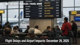
The FAA's Air Traffic Control System Command Center is managing a volume heavy travel day with targeted programs that can ripple nationwide. As of the FAA's midday planning snapshot, Naples Municipal Airport (APF) and Witham Field (SUA) are under ground delay programs for airport volume, and Newark Liberty International Airport (EWR) is showing a ground delay tied to wind and reduced visibility. Travelers should assume that a "local" delay today may actually be metering for downstream capacity, and build time buffers, monitor FAA program changes, and set a clear cutoff for when to rebook versus wait.
The FAA's planning advisory also keeps the Northeast and Mid Atlantic under watch for additional initiatives as ceilings, visibility, rain, and wind constrain terminal rates around the Boston, New York, Philadelphia, and DC complex. For the Great Lakes and Upper Midwest, Detroit Metropolitan Wayne County Airport (DTW), Chicago O'Hare International Airport (ORD), and Minneapolis St Paul International Airport (MSP) are dealing with snow tactically now, with DTW flagged as a candidate for a program later today if conditions tighten.
Who Is Affected
Travelers using South Florida gateways are the most directly exposed to volume driven programs today, especially anyone positioning into Naples Municipal Airport (APF) or Witham Field (SUA) on tight same day schedules. Even if you are not flying into those two airports, the Florida "snowbird" pattern can strain regional airspace and staffing, and that is why the FAA is also running multiple enroute flow constraints on Florida and Miami corridors that can delay departures far away from Florida.
Travelers connecting through the New York region, Boston, and Philadelphia should treat the afternoon and evening banks as higher risk than a typical winter weekday. Newark Liberty International Airport (EWR) is already posting an average delay, and the FAA's plan shows additional ground stop or delay initiatives as possible across Washington Dulles International Airport (IAD), EWR, General Edward Lawrence Logan International Airport (BOS), Ronald Reagan Washington National Airport (DCA), LaGuardia Airport (LGA), John F Kennedy International Airport (JFK), and Philadelphia International Airport (PHL) later today.
Ski travel itineraries are also in the crosshairs because demand concentrates into short arrival windows at mountain airports. Aspen Pitkin County Airport Sardy Field (ASE) is being monitored, and Eagle County Regional Airport (EGE) is already showing a volume related ground delay with an indicated end time around midday local time.
For continuity with yesterday's network setup, and the storm driven recovery dynamics that can keep crews and aircraft out of position, see Devin, Ezra Great Lakes Flights Disruptions Dec 28-30 and Flight Delays and Airport Impacts: December 28, 2025.
What Travelers Should Do
If you are traveling today, make your first move about buffers rather than optimism. For any itinerary involving South Florida positioning, the New York area, or a ski airport, treat a tight connection as a voluntary risk, and add time on the front end, whether that means an earlier flight, a longer connection, or an extra night near the airport. Use the FAA airport status pages to see when a ground delay is in effect, because that is often the earliest public signal that the system is metering arrivals.
Decide in advance when you will rebook instead of waiting. A practical threshold on a day like this is when your first leg is delayed enough to erase your connection buffer, or when the destination airport shifts from "on time" to an active ground delay program, because recovery can be slower than expected once the arrival rate is constrained. If your trip depends on a specific arrival window, for example a cruise embarkation, a resort transfer cutoff, or a last flight into a mountain airport, prioritize getting on an earlier flight, even if it is less convenient, because later banks absorb the day's backlog.
Over the next 24 to 72 hours, watch three things: whether Northeast initiatives move from "possible" to "probable," whether DTW shifts into an active program as snow and winds interact with runway rates, and whether Florida corridor flow constraints persist into the evening push. Also keep an eye on runway work in the New York area and other hubs, because capacity reductions during peak weeks can make a small weather wobble translate into multi hour schedule instability. For deeper system context on why these constraints propagate so quickly, reference U.S. Air Traffic Control Privatization: Reality Check.
Background
The FAA's Command Center manages demand when capacity drops, using tools like ground delay programs, ground stops, and enroute flow constraints that meter arrivals into constrained airspace. A ground delay program assigns expected departure clearance times so aircraft wait at their origin airports instead of stacking in airborne holding, which is safer, but it can feel counterintuitive to travelers because the delay often shows up before takeoff, not near the bad weather.
Today's pattern shows how disruptions propagate across layers. First order constraints are at the terminals, with volume programs in Florida, a wind driven delay at Newark, and potential low ceiling initiatives in the Northeast corridor. Second order effects appear in the connection network, as late inbound aircraft miss their next departure slot, crews time out, and hub banks lose their timing, which then drives rebooking pressure and overnight hotel demand in the same metro areas that are already capacity constrained. Third order effects show up in specialty markets like ski airports, where limited alternate lift and short operating windows mean a single delayed arrival wave can cascade into cancellations that are hard to recover the same day.