Flight Delays at US Airports, January 21, 2026
The FAA's Command Center outlook for the United States flagged a weather driven risk day centered on light snow in the Upper Midwest and Great Lakes corridor, wind in the Northeast corridor, and morning low clouds in parts of Texas and Southern California. Travelers connecting through Detroit Metropolitan Wayne County Airport (DTW), Minneapolis St Paul International Wold Chamberlain Airport (MSP), Chicago O'Hare International Airport (ORD), Chicago Midway Airport (MDW), Boston Logan International Airport (BOS), John F Kennedy International Airport (JFK), LaGuardia Airport (LGA), Newark International Airport (EWR), Philadelphia International Airport (PHL), Denver International Airport (DEN), Austin Bergstrom International Airport (AUS), San Antonio International Airport (SAT), Los Angeles International Airport (LAX), and San Diego Lindbergh Field Airport (SAN) sit in the highest exposure set. Next step is to check your airline's app for rolling schedule padding, then use FAA airport status pages to see whether flow programs are emerging before your departure bank.
Today's change, in plain traveler terms using flight delays US airports, is that multiple hub regions face weather constraints that can reduce arrival rates and push misconnect risk higher during peak banks.
FAA's ATCSCC operations plan added nuance that matters: Chicago's snow impact was described as minimal, MSP was removed from needing an initiative, and the only specific planned initiative called out was a possible San Diego ground stop or delay program after 1500Z. That combination points to a day where local airport conditions might look fine for long stretches, but a short, tactical traffic management move could still cascade into late afternoon and evening itineraries if it hits during a busy connection wave.
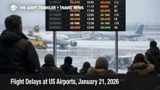
At the same time, FAA real time status pages for key airports were still reporting general arrival and departure delays at 15 minutes or less as of late morning to early afternoon UTC on January 21, 2026. That is encouraging, but it should be read as a snapshot, not a guarantee, because the FAA's own forecast framing is about expected operational impacts as conditions evolve through the day.
Who Is Affected
Same day flyers and tight connectors are the first group at risk, especially anyone relying on short connection windows at ORD, DEN, BOS, JFK, LGA, EWR, or PHL, where wind or snow can reduce arrival throughput and create gate conflicts. Travelers with itineraries that include regional jets into Midwest hubs are also exposed because light snow and deicing can slow turn times, which tends to compound across multiple legs rather than stay isolated at one airport.
The second group is travelers heading to or from Southern California, where low ceilings can trigger spacing, and where ATCSCC explicitly flagged a possible initiative at SAN after 1500Z. If your itinerary depends on SAN as a connecting point, or on a tight SAN arrival followed by a same day drive, tour pickup, or cruise embarkation, treat that time window as higher risk even if the morning looks normal.
A third group is anyone traveling through airports with reduced operational flexibility due to runway, taxiway, or construction constraints, because those constraints can stretch recovery when weather reduces capacity. ATCSCC's plan highlighted items like runway closures at Orlando International Airport (MCO) and other ongoing airfield projects, and those kinds of constraints matter most when an airport is trying to "catch up" after a flow program ends.
What Travelers Should Do
If you are flying today, build buffer where you can, and act early. For a connection itinerary, aim to protect at least a one hour domestic connection and a longer buffer for international legs, because the failure mode on weather constraint days is not only a late departure, it is an arrival that misses the last viable onward seat on a full flight. Check your airline's same day change options now, and make sure notifications are enabled in the airline app before you head to the airport.
Use a simple decision threshold: if your first leg is delayed enough that your connection margin drops below what you can comfortably walk in that terminal, or below what the airline typically protects during irregular operations, you should look for an earlier outbound, a later onward, or a reroute while inventory still exists. If airport status pages still show minimal delays and your aircraft is already at the gate with crew assigned, waiting can be reasonable, but if your flight is still missing an aircraft assignment or your inbound is late, you should assume compounding risk and move sooner.
Over the next 24 to 72 hours, monitor whether today's local constraints turn into network wide recovery problems, which can show up tomorrow as aircraft and crews being out of position. Keep an eye on ATCSCC advisories for new initiatives, and watch whether the airports called out today start showing sustained taxi or airborne delay categories rather than the current 15 minutes or less snapshot. If you are traveling internationally later this week, remember that Northeast wind constraints can spill into missed transatlantic connections, and your best protection is schedule slack rather than hoping for a perfect on time bank.
Background
The FAA Daily Air Traffic Report is a forecast oriented operational heads up: it highlights where weather or other factors may push the system toward arrival and departure delays, ground stops, or airport closures. On January 21, 2026, the core propagation story is familiar: light snow at Midwest hubs can slow runway acceptance rates and extend deicing queues, which then stretches taxi out times and reduces gate availability for arrivals, and that creates missed connections that radiate through the network. Wind in the Northeast can force less efficient runway configurations and larger spacing, which typically triggers traffic management initiatives that delay departures at origin airports so aircraft do not stack in holding near the destination metroplex.
Low clouds in Texas and Southern California add another layer: even when precipitation is not severe, ceilings can require instrument approaches and reduce arrival rates, and the operational response is often tactical, a short ground stop, or a delay program during a peak bank. ATCSCC's plan specifically called out a possible initiative for SAN after 1500Z, which is the kind of targeted action that can reshape late day rebooking options up and down the West Coast.
Finally, "background" constraints like runway closures, taxiway work, or ramp reconfigurations do not usually create delays on their own, but they reduce slack when the system is stressed. If a weather bank produces even a modest number of cancellations, constrained airports take longer to unwind the backlog, which is why a day that starts with minimal reported delays can still end with a challenging evening peak. For additional context on how small capacity cuts can cascade, see Flight Delays and Airport Impacts: January 20, 2026 and US Air Traffic Control Privatization Reality Check. If your routing includes Mexico or parts of Central America where dispatch decisions can affect timing and connections, also see FAA Mexico, Central America Flight Caution Through March.