Winter Storm Fern US Flights, Delays Linger Jan 26
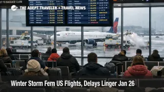
Winter Storm Fern is still disrupting U.S. travel as airlines work through a recovery that is uneven by region, with cold temperatures and lingering ice extending operational limits at major hubs. Travelers are most affected if they are connecting through the Northeast corridor or any carrier hub that lost large chunks of its schedule over the weekend, because cancellations and delays keep aircraft and crews out of position. The practical move is to treat January 26, 2026, as a recovery day rather than a normal travel day, rebook early under waivers when you can, and add more buffer than usual for both connections and airport access.
The Winter Storm Fern US flights update is that the system is no longer only about active precipitation, it is about restart friction, including deicing throughput, ramp safety pauses, and air traffic flow restrictions that can delay flights far from the storm footprint.
A key signal for Monday's lingering impacts is the FAA's operational outlook, which flags snow, high winds, and low clouds as delay drivers for Boston Logan International Airport (BOS), the New York area airports, and Philadelphia International Airport (PHL), plus high winds in the Washington, D.C., region and low clouds in Florida that can compound network recovery. Separate FAA system status messaging also points to the continued possibility of ground stop or delay programs as the morning push develops, which is how a hub problem turns into nationwide departure holds.
Public reporting and airline updates reinforce the same story: many cancellations were used to protect the next day's network, but the reset is constrained by where aircraft and crews ended up after Sunday's peak disruption. Even when airlines "resume operations," they often restart in phases, with partial schedules, delayed first departures, and high rebooking pressure on the remaining seats.
Who Is Affected
Travelers connecting through the largest hubs are exposed first, even if their origin and destination are outside the worst weather. When an arrival rate is capped at a hub, the system protects itself by delaying or canceling flights upstream, which creates missed connections, gate holds, and last minute aircraft swaps that are hard to predict from a local radar view.
Monday's problem set is also different by traveler type. Passengers with fixed arrival deadlines, cruise embarkations, prepaid tours, medical appointments, or same day business meetings are the most likely to face unrecoverable losses because "later today" options can disappear quickly once airlines start protecting recovery banks. Travelers on separate tickets remain especially vulnerable, because a misconnect can strand you without protected onward travel, even when the delay cause is clearly weather driven.
Ground access is part of the risk, not a side note. NOAA and National Weather Service messaging has emphasized that frigid air and ice can keep roads hazardous longer than a typical storm, which affects airport staffing, curb operations, baggage delivery, and the drive time you need to reach terminals. If your metro area is dealing with power outages, you should also expect less rideshare supply, longer hotel check in lines, and tighter last minute inventory near airports as stranded travelers extend stays.
What Travelers Should Do
If your itinerary touches a major hub, assume you need a bigger margin than usual. Check whether your ticket is covered by your airline's Winter Storm Fern waiver, then rebook before the best alternates disappear, and plan your airport arrival around slower security and slower gate turns on a recovery day. Keep essentials and medications in your personal item, and assume checked baggage delivery can lag if ramp work is slowed by ice, wind, or safety pauses.
Use a clear decision threshold for waiting versus rebooking. If your first flight is delayed and your connection drops under about 90 minutes at a hub, or if your hub is showing FAA flow constraints that morning, rebooking is usually safer than trying to thread a tight connection through a fragile network. If you must arrive the same day, prioritize routings with fewer hubs, longer connection windows, and earlier departures, even if the itinerary looks less convenient on paper.
Over the next 24 to 72 hours, monitor three layers that change quickly in winter recovery. First, local National Weather Service warnings for your counties, because refreezing and wind can keep roads and ramps hazardous after snowfall ends. Second, airline recovery updates and waiver extensions, because covered travel dates and eligible airports can shift as the network stabilizes. Third, FAA system status and the daily air traffic outlook, because ground stops and metering programs can turn a normal departure into a multi hour origin hold.
How It Works
Winter storms disrupt air travel in two phases, capacity loss during the event, then network fragility during recovery. At the source, snow and ice reduce the number of arrivals an airport can safely accept per hour because runway braking, visibility, and approach spacing become more conservative. On departures, deicing adds minutes per aircraft, and those minutes compound into gate congestion when multiple banks try to push at once.
Freezing rain and extreme cold are what make Fern linger. A thin glaze can shut down ramp work for safety even when runways are technically usable, and colder air slows thawing, which keeps deicing demand high and limits how quickly ground crews can clear aircraft, baggage, and equipment. That first order friction then becomes a second order cascade: aircraft end up in the wrong place for later segments, crews run into duty time limits, and airlines cancel additional flights to rebuild a workable rotation.
Those ripples spread beyond aviation. When flights misconnect, hotels near hubs fill faster, airport rental car inventories get distorted, and rideshare pricing spikes during peak rebooking waves. Rail and road alternatives can also be unreliable on the same days because icy roads, power outages, and weather related service reductions hit the very corridors travelers try to use as backups.
For continuity, travelers comparing the weekend peak to the Monday recovery can reference earlier Adept coverage in Winter Storm Fern US Travel Disruptions Jan 25 to 26 and Winter Storm Fern US Flights, Hubs Strained Jan 25-26.