Flight Delays and Airport Impacts: March 6
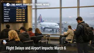
The FAA's March 6 air traffic outlook points to a broad, delay prone pattern rather than a single nationwide shutdown, with low ceilings and visibility expected to slow flights in Boston Logan International Airport (BOS), the New York metro airports, Philadelphia International Airport (PHL), the Washington area airports, Indianapolis International Airport (IND), Detroit Metropolitan Wayne County Airport (DTW), and Chicago O'Hare International Airport (ORD) plus Chicago Midway International Airport (MDW). Thunderstorms are also in play for Tampa International Airport (TPA) and Louisville Muhammad Ali International Airport (SDF), while rain and snow showers could complicate operations at Salt Lake City International Airport (SLC). For travelers, that means March 6 is a buffer day, not a tight connection day, especially if your itinerary runs through the Northeast, Chicago, Washington, DC, or a Florida bound flow lane. The FAA's operations plan also shows possible ground stop or delay programs later in the day for LaGuardia, Reagan National, Newark, Philadelphia, Atlanta, Denver, and both Chicago airports.
The key change from March 5 is that the FAA has widened the weather driven risk map into a multi region network problem. Instead of one or two isolated hubs carrying the burden, March 6 combines persistent morning visibility problems in the Northeast and Mid Atlantic with afternoon and evening traffic management risk stretching into Chicago, Washington, Atlanta, Denver, and Florida bound routes. In plain language, more flights may technically operate, but more of them are likely to be metered, rerouted, or held long enough to break onward plans.
Flight Delays March 6: What Changed for Travelers
The FAA Daily Air Traffic Report says the main operational drag on March 6 is low clouds and visibility in the Northeast and Midwest, with thunderstorms adding another risk lane in Tampa and Louisville, and mixed precipitation affecting Salt Lake City. That matters because low visibility reduces arrival rates at busy airports even when runways remain open. When fewer aircraft can land safely each hour, the system starts spacing flights farther apart, and those spacing rules ripple backward into departure holds at the origin airport.
The FAA Command Center's operations plan is more specific about where those slowdowns may harden into formal initiatives. It lists arrival delay advisories already issued for LaGuardia Airport (LGA) and Ronald Reagan Washington National Airport (DCA) because of low visibility, and it flags possible later ground stop or delay programs for DCA after 500 p.m. ET, LGA through the evening, Philadelphia after 500 p.m. CT, Newark Liberty International Airport (EWR) after 600 p.m. ET, Atlanta Hartsfield Jackson International Airport (ATL) after 600 p.m. ET, Chicago's airports through the late evening, and Denver International Airport (DEN) through the evening. That does not mean every program will be issued, but it is a real warning that the FAA expects demand and weather to push parts of the network close to their safe operating limits later today.
For Chicago specifically, March 6 lands on top of a broader capacity story. Reuters reported on March 5 that the FAA is considering deeper summer flight cuts at O'Hare because of schedule pressure and disruption risk, which matters here because a constrained hub is less resilient on marginal weather days. That does not create today's delays by itself, but it helps explain why ORD remains a fragile connection point when visibility drops and arrival rates tighten.
Which Travelers Face the Most Disruption
Travelers most exposed on March 6 are those with short same day connections through the Northeast corridor, Chicago, or Washington, plus passengers trying to reach Florida on later banked departures. The FAA operations plan says route structure has already been published for arrivals into Northeast markets and for Florida, with Jacksonville Center managing traffic using miles in trail, capping, and tunneling. That is technical language for flow control, the FAA is stretching spacing between aircraft and limiting how many flights can move through the same corridor at once. When that happens, the biggest loser is usually the tight connection, not the early morning nonstop.
Washington area trips deserve extra caution. The FAA daily report includes all three major airports serving the capital region, Washington Dulles International Airport (IAD), Reagan National, and Baltimore Washington International Thurgood Marshall Airport (BWI), in its delay risk zone. On top of that, the command plan specifically calls out DCA for low visibility related advisories and possible later traffic management action. If you are choosing between airports, Dulles or BWI may offer slightly better recovery options than Reagan National simply because the network into DCA is more slot constrained and more sensitive to metering.
Florida bound and Southeast itineraries also carry hidden risk even if your departure airport looks clear. The FAA says Florida flows may need structured routing, while the operations plan flags thunderstorms across multiple air route centers in the South and possible later initiatives at Atlanta. That means a traveler flying from the Midwest or Northeast to Florida can be delayed by en route congestion and reroutes, not just by weather over the destination. This is the kind of day when a flight remains "on time" until the system has to absorb a route change or meter arrivals, then suddenly slips enough to ruin an onward connection, cruise embarkation, or evening arrival plan.
What Travelers Should Do Now
For March 6 departures, the safest play is to protect time, not optimize schedule elegance. Travelers should leave more buffer for the airport, avoid checking bags if they can, and be especially cautious with connections under 90 minutes through New York, Washington, Chicago, and Newark. If you have a choice between an earlier and later departure on the same route, the earlier flight is usually the smarter bet on a day when the FAA expects initiatives to expand deeper into the afternoon and evening.
Rebook early if your trip depends on an evening arrival, a cruise embarkation, a tour with a hard check in cutoff, or the last practical flight of the day. Wait if your trip is flexible, you are on a nonstop, or your backup options tomorrow are still acceptable. The tradeoff is simple, waiting may preserve your original itinerary, but rebooking earlier can preserve the actual purpose of the trip. That is especially true for DCA, LGA, EWR, PHL, ORD, and MDW because the FAA has already flagged those airports for possible later programs.
Over the next 24 hours, monitor three things, not one. First, check whether your airport moves from "possible" initiatives to active ground delay or ground stop status on the FAA NAS page. Second, watch your inbound aircraft, because many March 6 disruptions will arrive as late equipment rather than an early cancellation. Third, keep an eye on security line variability if the federal shutdown continues to pressure TSA staffing ahead of heavier spring travel demand. Industry groups warned on March 5 that the shutdown is increasing reliability risk as spring volumes rise, which does not mean today's delays are caused by staffing, but it does mean the system has less slack if weather driven disruptions pile up. Flight Delays and Airport Impacts: March 5, DC Ground Stop Risk at Reagan National After 1 p.m., and U.S. Air Traffic Control Privatization: Reality Check offer useful context on how these slowdowns spread.
Why the Disruption Spreads Through Travel
The mechanism on March 6 is mostly throughput reduction, not airport closure. Low ceilings and low visibility force controllers to increase spacing, which lowers the number of arrivals and departures an airport can safely handle in a given hour. Once that happens at several hubs at once, airlines lose the timing they need to keep aircraft, crews, gates, and connection banks aligned. The first order effect is visible delay at the affected airport. The second order effect is much broader, late inbound aircraft, missed connections, tighter rebooking inventory, baggage arriving on a later flight, and more hotel pressure for travelers who miss the last viable departure.
March 6 also has a route structure problem, not just an airport problem. The FAA says it has published special route structure for Northeast arrivals and Florida traffic, while southern air route centers face thunderstorm constraints. That means the network may reroute aircraft around weather or meter them into narrower corridors. Even travelers who never touch Boston, New York, or Tampa can still feel the impact if their aircraft or crew is arriving from those constrained flows. That is why daily FAA outlooks matter, they show where the system is likely to bend before passengers see the delay show up on the departure board.
Sources
- FAA Daily Air Traffic Report, Friday, March 6, 2026
- FAA Current Operations Plan Advisory, ATCSCC ADVZY 034 DCC 03/06/2026
- National Airspace System Status, FAA
- FAA Seeking Steeper Cuts in Flights at Chicago O'Hare Airport, Sources Say, Reuters, March 5, 2026
- Airline and Travel Groups Warn of Risks to Air Traffic as Partial Shutdown Persists, Reuters, March 5, 2026