Delta East Coast Weather Waiver Opens March 16 To 17
Delta East Coast weather waiver now matters before the worst disruption fully shows up. Delta posted an Eastern North America weather advisory on March 14 for travel on March 16 to 17, 2026, covering a long airport list from Hartsfield Jackson Atlanta International Airport (ATL) through the New York and Washington airport banks to Boston Logan International Airport (BOS), Montreal Trudeau International Airport (YUL), and Toronto Pearson International Airport (YYZ), with reissue and new travel flexibility through March 24. That is a much larger preemptive footprint than a normal single city waiver, which gives travelers a real chance to move early instead of waiting for same day failures. The practical decision is simple, nonstop travelers may be able to wait longer, but anyone depending on Atlanta, New York, Boston, Philadelphia, or Washington connections should price a proactive switch now.
The change since prior coverage is that the story has moved from airport by airport delay risk into a carrier wide prepositioning signal. Delta is not just reacting to active cancellations, it is opening a broad waiver before March 16 operations begin, which usually means the airline sees enough network risk to give customers room to self solve ahead of the crunch. That matters more than a narrow airport advisory because East Coast weather does not stay local when it hits dense connection banks.
Delta East Coast Weather Waiver: What Changed
The published waiver covers travel on March 16 and March 17, with eligible tickets issued on or before March 14. Delta says travelers who rebook and complete new travel on or before March 24 in the same cabin can generally avoid the fare difference, though class to class restrictions can still matter if the original booking class is unavailable. If travel moves beyond March 24, the change fee can still be waived, but any fare difference may apply. Delta also says customers can cancel and preserve the unused ticket value for one year from original issuance if they cannot reschedule within the waiver window.
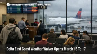
The airport footprint is the real headline. The list includes ATL, Baltimore Washington International Thurgood Marshall Airport (BWI), BOS, YUL, John F. Kennedy International Airport (JFK), LaGuardia Airport (LGA), Newark Liberty International Airport (EWR), Philadelphia International Airport (PHL), Ronald Reagan Washington National Airport (DCA), Washington Dulles International Airport (IAD), and dozens of secondary spoke airports across the Mid Atlantic, Carolinas, Georgia, upstate New York, New England, and eastern Canada. That tells travelers Delta expects network risk across both major hubs and feeder cities, not just one storm target.
Which Travelers Face the Most Disruption
The most exposed travelers are not necessarily the ones flying into the worst weather first. They are the ones whose itineraries depend on fragile connection geometry. ATL is the biggest risk bank in this waiver because Delta uses it as its main Southeast engine, so weather there can scramble aircraft rotations and crew flow far beyond Georgia. The New York, Boston, Philadelphia, and Washington airports create a second risk cluster because those airports are dense, delay prone, and heavily interconnected with short haul feeders and long haul departures. A line of storms or flow restrictions in one piece of that corridor can push late aircraft and late crews into the next bank quickly.
This is why a preemptive waiver matters more for connecting passengers than for simple local nonstops. A traveler going Chicago to Atlanta to Savannah, or Raleigh to JFK to Europe, can lose the whole itinerary even if only one segment takes the first hit. The same is true for travelers trying to reach cruise ports, same day business meetings, or a protected long haul departure out of JFK, Boston, or Washington. Adept's recent Flight Delays and Airport Impacts: March 14 and Washington ATC Outage Delays DCA, IAD, BWI, RIC coverage already showed how modest disruptions in the Northeast and Mid Atlantic can spread through crowded airspace and inherited aircraft timing.
What Travelers Should Do Now
For March 16 departures, proactive rebooking beats waiting when your trip depends on a tight connection, a late afternoon or evening bank, or a must make event on arrival. The best use of this waiver is not chasing a better seat, it is removing connection risk while the carrier is still offering flexibility. Travelers with nonstop service or an overnight buffer at destination can afford to wait longer, but travelers connecting through ATL, JFK, LGA, EWR, PHL, DCA, IAD, or BOS should treat this as a decision window, not a courtesy notice.
In plain English, the rules mean this. If you move the trip and start the new itinerary by March 24, Delta will generally waive the extra fare in the same cabin, subject to booking class limits. If you push later than March 24, you may still avoid the change fee, but you can end up paying more for the new fare. That makes early action more valuable on routes where prices could rise once disrupted passengers start competing for fewer seats.
Over the next 24 to 72 hours, watch three things. First, whether Delta broadens the waiver or updates the airport list. Second, whether National Weather Service offices continue to emphasize damaging wind and tornado risk in the Southeast and Carolinas, or heavier rain and wind farther north into the Mid Atlantic and Northeast. Third, whether other carriers start matching the same geography and timing, which usually confirms that the disruption is becoming a network event rather than one airline's internal hedge. Travelers should also remember the structural capacity problem, because when aircraft and crews fall out of sequence, recovery is slower in a market with less spare lift, a dynamic explained in FAA Delays on Boeing 737 MAX 10 Hit Airline Capacity.
Why This Is Happening
The weather setup is broad enough to justify a broad waiver. National Weather Service briefings for central North Carolina on March 16 show a moderate, level 4 of 5, severe storm risk, while the Atlanta forecast office says confidence is increasing in severe weather from late March 15 into March 16 with damaging winds and a few tornadoes possible. The Wakefield, Virginia, office also warns of strong thunderstorm wind gusts around the frontal passage, and the Weather Prediction Center flags a marginal excessive rainfall risk for parts of the Mid Atlantic and Northeast from March 16 into March 17. Put simply, this is not one airport's thunderstorm problem. It is a moving corridor of wind, convection, and rain that can degrade operations in sequence from the Southeast into the Northeast.
That sequence matters because airlines do not operate airports one by one. They operate rolling banks of aircraft, crews, gates, and onward passengers. The first order effect is delayed or canceled departures in the weather zone. The second order effect is what travelers usually feel later, late inbound aircraft, crews timing out, missed onward connections, shrinking same day rebooking inventory, and rising pressure on nearby hubs that were not the original failure point. When Delta opens a waiver that stretches from Georgia through the Northeast and into eastern Canada, it is effectively acknowledging that this storm corridor threatens the network shape itself, not just one local station.