March 26 Weather Delays Shift to New York, Chicago
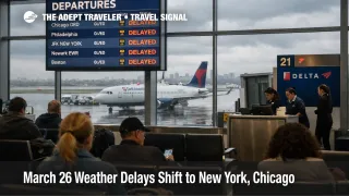
March 26 weather delays are shifting toward New York and Chicago after the Federal Aviation Administration warned of wind around John F. Kennedy International Airport (JFK), LaGuardia Airport (LGA), Newark Liberty International Airport (EWR), and Philadelphia International Airport (PHL), while thunderstorms threaten Chicago O'Hare International Airport (ORD), Chicago Midway International Airport (MDW), Detroit Metropolitan Wayne County Airport (DTW), and Denver International Airport (DEN). The practical risk is not a single nationwide collapse. It is a split weather day that can look manageable at midday, then tighten quickly as the afternoon and evening banks stack up. Travelers with short connections, same day meetings, cruise embarkations, or separate tickets should make earlier decisions than they did on March 25.
March 26 Weather Delays: What Changed
The main change since Wednesday, March 25, is the center of gravity. On March 25, the FAA described favorable national flying conditions with more localized friction points. On Thursday, March 26, the FAA's daily report explicitly shifted the day's warning map toward wind in the New York system and Philadelphia, plus thunderstorms in Chicago, Detroit, and Denver. The FAA's current operations plan goes further, listing possible ground stop or delay programs for JFK and Newark after 100 p.m. EDT, Denver after 500 p.m. MDT, and ORD and MDW after 5:00 p.m. CDT.
That split matters because New York and Chicago do not fail the same way. Wind in the New York and Philadelphia flow tends to cut arrival rates and stretch spacing in dense airspace, while Chicago thunderstorms can force reroutes, arrival compression, and later inbound aircraft problems that spill into evening departures. The FAA's live airport pages were still showing only modest arrival delays at several hubs when checked, which is exactly why the decision window is earlier than the visible disruption window. By the time airport boards look ugly, rebooking inventory is already thinner.
Which Airports and Trips Face the Most Risk
New York travelers are the most exposed if they are connecting, flying late in the day, or depending on LaGuardia to operate like a normal shuttle market. The FAA plan still shows New York with less recovery slack than a routine Thursday because LGA already carried an early ground delay program, JFK remains under taxiway closures through 10:00 p.m. UTC on March 26, and JFK and Newark are both flagged for possible later ground programs. Philadelphia sits in the same wind zone, so even travelers not touching New York can feel the same airspace drag on Northeast itineraries.
Chicago is the higher risk play for travelers whose day depends on the evening bank holding together. The FAA's March 26 plan lists convective weather for the Chicago, Detroit, and Denver corridor, and it specifically says ORD and MDW could move into a ground stop or delay program after 5:00 p.m. CDT. United has an active Chicago thunderstorms waiver for ORD for March 26 travel, and American has a severe weather Chicago alert that lets eligible ORD travelers rebook between March 25 and March 28 without a change fee, subject to fare rules.
Waiver geography also matters. American's current alerts still include a New York LaGuardia waiver covering March 23 through March 28 travel, with rebooking allowed through March 30 and alternate New York area airports permitted in some cases. That waiver is tied to the earlier LaGuardia disruption, not Thursday's weather alone, but for travelers it still functions as useful flexibility in a metro area where the FAA is again signaling weather pressure.
What Travelers Should Do Before Afternoon Delays Build
Travelers departing New York or Chicago later on Thursday should check two things before deciding whether to wait or move, the inbound aircraft, and the waiver. If the inbound plane is already late, your connection is under about 90 minutes, or your trip depends on a fixed arrival such as a cruise embarkation, event, or same day business return, the safer move is to rebook while waiver inventory still exists. If you are flying nonstop, have schedule slack, and the inbound aircraft is moving on time, waiting can still be the better trade.
For New York, the threshold is earlier because wind related flow limits often degrade the whole metro system before a single airport looks disastrous. For Chicago, the threshold is later but steeper because thunderstorm days can move from manageable to cancellation prone once reroutes and gate conflicts start compounding. Philadelphia travelers should think more like New York travelers, while Detroit and Denver travelers should think more like Chicago travelers, watch the afternoon build, and avoid tight onward plans.
Anyone who chooses to stay on the original itinerary should build extra ground time at both ends. The first order effect is a delay. The second order effects are harder, missed onward flights, tighter hotel inventory near hub airports, and thinner same day rebooking options once the late banks start to bunch. That risk is especially acute on separate tickets and on hub connections where the next viable departure may be the following morning.
Why New York and Chicago Could Spread Delays Tonight
The mechanism is straightforward. New York concentrates a huge amount of traffic into constrained airspace, so wind can reduce throughput even when storms are not sitting on top of the field. Chicago is one of the country's biggest connection complexes, so thunderstorms there do not just delay local passengers, they also knock aircraft and crews out of position for later departures across the network. The FAA's current plan reflects that difference by flagging New York for earlier possible flow programs and Chicago for later convective escalation.
In an earlier Adept Traveler article, Flight Delays and Airport Impacts: March 25, the main point was that the national map had calmed even though airport specific weak points remained. March 26 is different. The broad weather split is back, and the waiver map has moved with it. Travelers who want more structural context on why U.S. hub delays propagate so quickly can also read U.S. Air Traffic Control Privatization: Reality Check, which explains how limited slack in the FAA system turns localized constraints into wider itinerary problems.
What happens next depends on whether the predicted afternoon programs become active and whether carriers can keep late inbound aircraft from snowballing into evening cancellations. The clearest warning signs are simple, ground delay programs actually posting for JFK, EWR, ORD, or MDW, inbound aircraft falling behind schedule, and airlines tightening rebooking availability before departure time. If those signals appear, Thursday stops being a nuisance delay day and turns into an overnight risk day in both the Northeast and the Midwest.