Flight Delays and Airport Impacts: March 28
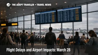
March 28 flight delays are concentrated in a smaller set of U.S. pressure points than a true coast to coast disruption day, but the FAA is flagging enough separate constraints to make short connections and late day recovery harder. The clearest live signal is at LaGuardia Airport (LGA), where the FAA says a traffic management program is delaying some arriving flights by an average of 18 minutes. The broader FAA operations plan also points to New York wind, Detroit snow, low ceilings in Southern California, thunderstorms in the Washington and Atlanta corridor, and possible ski country delay programs later in the day. For travelers, this is a buffer day, not a panic day. Protect tight connections, and do not assume a quiet departure board early in the day means the evening bank will hold.
March 28 Flight Delays: What Changed
The March 28 setup is more fragmented than the March 27 pattern. Instead of one or two obvious weather centers dominating the national map, the FAA's current operations plan shows several smaller drag points that can combine into a harder travel day, wind in the New York approach system, snow around Detroit Metropolitan Wayne County Airport (DTW), low ceilings affecting Los Angeles International Airport (LAX) and San Diego International Airport (SAN), thunderstorms affecting Washington and Atlanta overflight structure, and heavier ski country volume later in the day. That matters because fragmented disruption is easier to underestimate. Travelers see modest delays at their origin, then lose time later when arrival spacing, reroutes, or aircraft rotation problems catch up.
There is one important improvement signal. The FAA's most recent advisory shows the earlier George Bush Intercontinental Airport (IAH) ground delay program was canceled after the agency said the objective had been met. That does not make Houston risk free, but it does mean one early pressure point eased instead of widening. By contrast, LaGuardia still carried an active traffic management program when checked, which makes the New York system the more concrete live issue at this stage.
In an earlier Adept Traveler article, Flight Delays and Airport Impacts: March 27, the FAA picture was already narrower than the broader March 26 weather split. March 28 is narrower still, but that does not automatically make it cheaper or easier for connecting passengers. A targeted delay day can still be expensive when it hits New York flows, ski traffic, or late departures with little recovery slack.
Which Travelers and Airports Face the Most Risk
The most exposed travelers are people connecting through LaGuardia or the wider New York system, passengers heading into San Diego or Southern California later in the day, Detroit travelers dealing with snow related friction, and anyone using Denver area or mountain airport itineraries that depend on ski country flying staying fluid into the afternoon and evening. The FAA plan specifically lists possible San Diego ground stop risk through 1700Z and possible ski country ground stop or delay program risk through 0000Z.
What makes this day tricky is that many live airport pages still look relatively manageable. When checked, Chicago O'Hare International Airport (ORD), John F. Kennedy International Airport (JFK), San Diego, Los Angeles, Denver International Airport (DEN), and Detroit were all showing either no destination specific delays or only general gate hold, taxi, or airborne delays of 15 minutes or less. That is exactly the kind of setup that misleads travelers into waiting too long. By the time a modest weather or flow issue turns into a visible airport board problem, same day rebooking options are already thinner.][5])
Origin passengers and connecting passengers do not carry the same risk. If you are starting at a constrained airport, the failure point is usually the airport process itself, security, check in, or boarding flow. If you are connecting, the bigger risk is that a modest upstream delay pushes the first flight late enough to break the onward segment. That is especially true on separate tickets, on the last practical flight of the day, or on trips tied to cruises, tours, or fixed arrival events. In an earlier Adept Traveler signal, Airport Security Delays Could Outlast the Shutdown, the warning was that checkpoint pressure could remain a separate risk layer even when the FAA flow picture looked manageable. That still applies on March 28.
What Travelers Should Do Now
Treat this as a decision timing day. If your itinerary depends on a short connection through New York, a late arrival into San Diego, or a mountain airport connection after midday, protecting time is more valuable than waiting for a bigger headline. Rebooking early makes the most sense when your connection is already tight, your inbound aircraft is late, or your trip depends on a fixed arrival. Waiting can still be reasonable if you are flying early, nonstop, and your airport is still showing only minor delays.
The threshold is different by market. New York delays tend to spread through constrained airspace and arrival spacing, so the penalty often appears before a single airport looks disastrous. Southern California low ceiling days can stay mild, then tighten quickly at specific airports. Ski country volume can look normal until late banks and mountain demand stack together. Travelers should make their choice based on schedule vulnerability, not on whether the first status check looks calm.
The next things to watch are simple. Watch for LaGuardia delay averages rising, San Diego moving from possible to active traffic controls, and ski country programs actually posting later in the day. Also watch your inbound aircraft, not just your own departure. That is often the earliest sign that March 28 flight delays are about to spread from a localized FAA issue into a broader itinerary problem. Travelers who want more system context can read U.S. Air Traffic Control Privatization: Reality Check.
Why the Pressure Can Spread Later
The mechanism on March 28 is not one giant shutdown of the network. It is a chain of smaller constraints that can interact. Wind in New York reduces throughput in dense airspace. Snow around Detroit can slow sequencing and surface movement. Low ceilings in Southern California can compress arrival and departure rates. Thunderstorms in the Washington and Atlanta corridor can tighten routing. Heavy ski country volume can then hit a system that already has less slack. First order, travelers see delays. Second order, aircraft and crews slip out of position, and later departures become harder to recover.
That is why the live airport pages can still look fairly good while the real risk remains later. On fragmented disruption days, the travel system usually breaks at the margin first. The early sign is not always a cancellation burst. It is thinner connection time, slower arrivals, reroutes, and a reduced margin for error. March 28 flight delays are still more manageable than a major national weather day, but they are serious enough to punish tight schedules and late decisions.