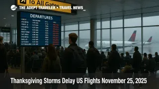
Thanksgiving Storms Delay US Flights November 25 2025
Thanksgiving storms US flights are already rippling through the system on November 25, 2025, with the Federal Aviation Administration's Daily Air Traffic Report flagging thunderstorms and low clouds at John F. Kennedy International Airport (JFK), LaGuardia Airport (LGA), Newark Liberty International Airport (EWR), Philadelphia International Airport (PHL), George Bush Intercontinental Airport (IAH), William P. Hobby Airport (HOU), and Memphis International Airport (MEM) on the single busiest flying day in 15 years, when more than 52,000 flights are scheduled. Travelers connecting through these hubs, as well as Hartsfield Jackson Atlanta International Airport (ATL), Chicago O Hare International Airport (ORD), Seattle Tacoma International Airport (SEA), Dallas Fort Worth International Airport (DFW), and Washington area airports, face a heightened risk of ground delays, holding patterns, and missed onward connections as storms and low visibility work across multiple regions. Anyone with tight connections today should build in extra buffer time, favor nonstop flights where possible, and be ready to rebook if their first leg slips.
In practical terms, the Thanksgiving storms US flights forecast means that a pair of overlapping systems, one featuring heavy rain and severe thunderstorms across the South and Gulf Coast and another driving snow and strong winds into the Upper Midwest and Great Lakes, will reduce the margin for error across already full holiday schedules, especially along the Northeast and Gulf corridors.
National forecasts from major outlets show rain and thunderstorms pushing from the Mississippi Valley toward the East Coast during the day on November 25, sweeping over big city airports from Houston and Atlanta to New York and Philadelphia. In the South, forecasters warn of severe storms with damaging winds and heavy rain from parts of Texas and Louisiana into Mississippi, Alabama, and Georgia, a setup that often produces ground stops and miles in trail spacing for arrivals into Houston and Atlanta. Farther north, a strengthening low is moving from the northern Plains into the Great Lakes between November 25 and 27, bringing lake effect snow and strong winds that can slow or briefly halt operations at Minneapolis, Detroit, and secondary Midwest airports and cause reroutes or longer routings for flights crossing that airspace.
The FAA's outlook for November 25 focuses on convective weather around the New York metro airports, Philadelphia, Houston, and Memphis, with low clouds and potential instrument flight rule conditions in the Dallas Fort Worth area. Those same hubs sit at key nodes in the national network, which means that ground delay programs or arrival metering there can cascade quickly to secondary airports. A ground stop at New York, for example, often pushes holding or delays as far away as Florida, the Caribbean, and the central United States, while a constrained Houston corridor can back up traffic from Mexico and Central America.
Forecasts from The Weather Channel and other national services stress that impacts will not be limited to the South and Northeast. Their Tuesday airport impact maps highlight Atlanta, Chicago, Dallas Fort Worth, Houston, New York City, Philadelphia, Seattle, Minneapolis, and Washington, D.C., as likely to see at least some delays as rain and snow move through different sectors of the country. On Wednesday, November 26, attention shifts more squarely to the Northeast and Great Lakes, with lingering showers near New York and Boston and heavier snow around the upper Mississippi Valley and the lake belts, conditions that can complicate both runway operations and deicing sequences.
All of this weather is hitting a system that has just come off an unprecedented 43 day federal government shutdown and a period of FAA imposed flight cuts at 40 major airports. The shutdown, which ran from October 1 to November 12, 2025, forced air traffic controllers to work without pay and led to chronic staffing strains at key facilities. To protect safety, the FAA ordered airlines to trim domestic schedules by up to 6 percent at the busiest hubs starting November 7, a plan that was initially supposed to ramp toward 10 percent cuts before improving staffing allowed the agency to freeze reductions at 6 percent and then cancel the emergency order. Those flight caps were lifted at 6:00 a.m. on November 17, letting carriers restore normal schedules just in time for Thanksgiving, but officials and analysts caution that controller rosters and training pipelines remain under pressure.
For travelers, that combination of full schedules, recently lifted caps, and complex storm patterns means there is less slack in the system if something goes wrong. When controllers have to space out arrivals around thunderstorms or low visibility, or when snow briefly closes a runway, there are fewer empty seats later in the day to absorb rebookings. The FAA estimates that more than 360,000 flights will operate over the Thanksgiving period, with more than 52,000 of them on November 25 alone, numbers that match or exceed the pre pandemic holiday peaks. AAA and other forecasters expect about 82 million people to travel at least 50 miles for the holiday, including a record number flying home on the Sunday after Thanksgiving, so any disruption on Tuesday can easily echo into later in the week.
Background
The FAA Daily Air Traffic Report is a short operational briefing that highlights the main weather and traffic constraints across the National Airspace System each day. It notes where thunderstorms, low ceilings, or other factors may require traffic management initiatives, such as ground delay programs, ground stops, or reroutes, and it often lists specific large hubs and metroplexes such as the New York airports, Atlanta, or the Houston pair that are likely to see impacts. Airlines use this report, along with their own meteorology teams and the FAA's dynamic advisories, to decide when to pre cancel flights, upgauge certain routes, or adjust crew and aircraft rotations.
Weather driven disruptions normally hit hardest at banks of tightly timed connecting flights. At Hartsfield Jackson, for example, afternoon and early evening banks funnel large numbers of passengers through relatively narrow windows, so any convective line or low cloud deck that slows departures or arrivals can spill connections into the next bank and force overnight stays. At the New York airports, the combination of intersecting runways, noise abatement procedures, and dense overlapping flows from Europe, the domestic network, and the Caribbean means that thunderstorm cells over just a few fixes can cut arrival rates sharply until they pass.
In the Gulf and lower Mississippi Valley, stronger storms bring their own hazards. Embedded supercells or squall lines near Houston, Memphis, or New Orleans can trigger diversions and longer routings around the worst weather, adding fuel burn and time. On the cold side of the system, lake effect snow bands around the Great Lakes can swing quickly over specific runways or approach paths, reducing visibility and friction to the point that crews must pause operations until plows and deicing teams catch up.
Given that backdrop, travelers who still have flexibility on November 25 should think less about the nominal scheduled time and more about exposure to those choke points. A mid morning connection through New York, Philadelphia, or Houston today will be more vulnerable than a nonstop flight later in the evening or a connection that uses a clearer hub in the interior of the country. Likewise, itineraries that rely on the last regional departure of the night from a spoke city into a hub are risky if the inbound aircraft must traverse storm affected airspace.
For those already locked into their plans, the priority is to stay ahead of the changes. Airline and airport apps are the first place delays and gate changes appear, often before email alerts. Travelers should check their reservation at least several hours before leaving for the airport, verify that both legs of any connection remain intact, and consider using same day change tools to move onto earlier flights if storms are expected to worsen as the day goes on. At the airport, moving carry on only and accepting an offered reroute through a less weather exposed hub can be far better than waiting for a perfect nonstop that may never depart.
International travelers heading into the United States today, particularly those landing in New York, Atlanta, Chicago, or Houston, should allow extra time for connecting to domestic legs, because customs and immigration clearance can be another bottleneck when storms slow arrivals and back up queues. Where possible, building an overnight stop in the gateway city, or at least four to five hours of buffer between an inbound long haul and a domestic connection, will reduce the risk of being stranded mid journey.
If your trip allows it, you can also shift nonessential travel into Saturday afternoon or early next week, when current forecasts suggest a relative lull between the departing Thanksgiving systems and whatever pattern sets up for early December. For essential trips that must happen today, the most practical step is to plan as if a delay is likely, pack patience, and build backup options for overnight stays and onward ground transport.
Within the Adept Traveler ecosystem, you can pair this national view with our daily FAA focused advisory, Flight Delays And Airport Impacts: November 25, 2025, for a more granular airport by airport snapshot, and compare today's pattern with the lead in from November 24 to understand how traffic management initiatives are evolving.
Sources
- FAA Daily Air Traffic Report
- FAA Expects Busiest Thanksgiving Travel Period in 15 Years
- Thanksgiving Travel Weather Forecast, Any Impacts on US Airports
- Thanksgiving US Travel, Storms Blizzard and Fog to Disrupt Millions
- Thanksgiving Travel Forecast, Where Weather Delays Could Be Encountered
- Thanksgiving Air Travel Plans Cut by US Government Shutdown
- FAA Lifts Order Slashing Flights, Allowing Commercial Airlines to Resume Their Regular Schedules
- Regulatory Alert, FAA Issues Emergency Order Restricting Air Traffic at 40 Airports