Thanksgiving Winter Storms Hit US Flights And Roads
US holiday travelers now face a messy mix of real time flight delays, dangerous driving, and a second storm on the way, because Thanksgiving winter storms are hitting US flights and roads around some of the busiest travel days of the year. Live trackers show more than 2,000 flights delayed as snow, high winds, and low visibility spread from the Northern Plains into the Great Lakes, while blizzard and lake effect warnings stretch across parts of Wisconsin, Michigan, Ohio, Pennsylvania, and New York.A follow on system is forecast to organize over the Rockies on Friday, then sweep through the Plains, Midwest, and into the East Coast over the weekend, overlapping directly with the main Thanksgiving return travel window.
In practical terms, this means Thanksgiving winter storms are likely to disrupt US flights and long road trips from Wednesday 26 November through at least Sunday 30 November, with the worst risk focused on Saturday in the Midwest and Sunday along the Eastern seaboard.
How The First Storm Is Hitting Thanksgiving Travel
The first winter storm swept out of the Dakotas and Upper Midwest on Wednesday, dropping more than half a foot of snow in places and producing whiteout conditions along parts of Interstates 29, 90, and 94.FOX Weather describes it as the biggest lake effect event of the season so far, with blizzard warnings in Michigan's Upper Peninsula and gale conditions on Lake Superior, and notes that feet of snow are possible in some snowbelt communities by Friday.
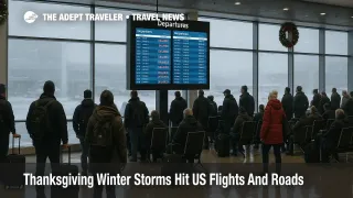
By early Wednesday and into Thursday morning, Newsweek's live tracker and other outlets citing FlightAware data reported more than 2,000 flights delayed as the first storm tangled operations at large hubs, with ripple effects across the national network.Weather driven disruption has piled onto existing congestion, so travellers are seeing longer lines at check in, gate changes, and short notice retimings even where snow is not falling overhead.
At the surface, the National Weather Service highlights heavy lake effect snow, gusty winds, and localized blizzard conditions near and downwind of the Great Lakes through Thanksgiving Day, especially in parts of Wisconsin, Michigan, Ohio, Pennsylvania, and western and central New York.That pattern is especially dangerous because conditions can flip from clear pavement to whiteouts over a few miles as narrow snow bands shift.
Key Airports And Flight Patterns At Risk
Storm impacts are already being felt at major hubs in the Upper Midwest and Great Lakes, and forecasts point to a widening ring of risk as the second system arrives. FOX Weather and AccuWeather both flag Chicago O Hare International Airport (ORD), Milwaukee Mitchell International Airport (MKE), and Detroit Metropolitan Wayne County Airport (DTW) as high exposure hubs for snow, strong crosswinds, and potential ground stops as the weekend storm matures.
The Weather Channel's national Thanksgiving forecast adds detail, listing major airports with elevated disruption risk by day. On Thursday and Friday, Cleveland Hopkins International Airport (CLE), Seattle Tacoma International Airport (SEA), and Portland International Airport (PDX) are singled out for lake effect bands and Pacific systems. By Saturday, the list expands to Chicago O Hare, Dallas Fort Worth International Airport (DFW), Detroit, Houston's George Bush Intercontinental Airport (IAH), Kansas City International Airport (MCI), Minneapolis Saint Paul International Airport (MSP), and St Louis Lambert International Airport (STL), with snow and thunderstorms expected to trigger both airside and ramp delays.
On Sunday, as the second storm's rain shield spreads along the Eastern seaboard, The Weather Channel warns that hubs at Hartsfield Jackson Atlanta International Airport (ATL), Denver International Airport (DEN), Boston Logan International Airport (BOS), New Orleans Louis Armstrong International Airport (MSY), the three main New York airports, Orlando International Airport (MCO), Philadelphia International Airport (PHL), Pittsburgh International Airport (PIT), and the Washington area airports could all see significant arrival and departure delays.Even where precipitation falls mainly as rain, low ceilings, wind, and congestion can slow arrival rates far below normal schedules.
For travellers connecting from Europe or the Pacific, the practical consequence is that itineraries routed through Chicago, Minneapolis, or Detroit on Saturday, or through New York, Boston, or Washington on Sunday, carry a significantly higher misconnect risk than usual.
Lake Effect Snow Belts And Road Corridors
On the roads, the lake effect side of the pattern is already creating life threatening conditions in classic snowbelt zones. FOX Weather highlights blizzard conditions along parts of Michigan's Upper Peninsula and notes that narrow but intense bands will focus on stretches of Interstate 90 across Ohio, Pennsylvania, and New York, plus portions of Interstates 94, 75, and 69 in Michigan, where whiteouts and drifting snow can make travel impossible at times.
Along the eastern Great Lakes, lake effect snow warnings and winter storm warnings cover areas from northeast Ohio through northwest Pennsylvania into western and north central New York, including communities near Buffalo, Syracuse, and the Tug Hill Plateau, with localized totals that could exceed one to three feet in the most persistent bands.State and local agencies are already reporting power outages, jackknifed trucks, and partial closures on secondary highways.
Drivers who planned same day turns between cities like Cleveland and Buffalo, or who intended to use overnight runs between Chicago, Grand Rapids, and northern Michigan, now face a much higher chance of full closures or lengthy delays, especially Wednesday night through Friday morning.
Second Storm To Hit The Return Travel Window
While the first winter storm is primarily a Thanksgiving Day and immediate lead in problem, the second storm is timed to hit when people are trying to get home. AccuWeather forecasts a snowstorm forming over the Rockies on Friday, then tracking across Colorado, the central Plains, and into the Midwest, with a broad swath of six to twelve inches of snow from southeastern South Dakota through Iowa, southern Minnesota, northwestern Illinois, southern and central Wisconsin, and into central and northern Lower Michigan.
Cities such as Des Moines, Madison, and Grand Rapids sit inside the current heavy snow corridor, while Chicago is close enough that a modest track shift could turn a nuisance event into a serious airport disruption.South of the snow zone, a corridor from central Missouri through central Ohio into western New York is expected to see periods of heavy rain and mixed precip, with the potential for quick transitions between snow, sleet, and rain, followed by a temperature drop that can leave black ice on bridges and untreated ramps.
The Weather Channel and FOX Weather both emphasize that Saturday will likely be the most disruptive day for Midwest air travel, with Sunday afternoon and evening posing the greatest risk for East Coast hubs as the system's rain and low clouds spread across the Interstate 95 corridor.The National Weather Service Weather Prediction Center explicitly warns that a significant winter storm early this weekend could threaten post Thanksgiving travel across the central and upper Midwest into Lower Michigan.
How This May Ripple Through The Network
For airlines, the combination of back to back systems and peak Thanksgiving demand leaves little slack. AccuWeather notes that aircraft and crews displaced by the Midwest storm may create ripple effects nationwide, even at airports where the weather itself is manageable.Once Chicago O Hare, Minneapolis, or Detroit start to build long queues for de icing and departure, connections through southern hubs such as Atlanta, Dallas Fort Worth, Houston, Charlotte, and Miami can suffer as inbound legs arrive late and crews bump up against duty limits.
Sunday is already projected as the single busiest air travel day of the Thanksgiving period, so East Coast hubs will be operating near capacity even before rain, low cloud, and residual Midwest delays are layered in.Travellers using the New York airports, Boston Logan, Philadelphia, Washington National, or Dulles should assume that even on time arrivals may spend longer in holding patterns and longer taxiing on the ground.
Practical Advice For Flyers And Drivers
Given the forecast evolution, the safest moves now are about timing and routing. Travellers who have the option to return Monday instead of Sunday, particularly on itineraries that connect through Chicago, Minneapolis, Detroit, or major East Coast hubs, can materially reduce their exposure to delays, missed connections, and involuntary overnight stays.
Those who must travel Saturday or Sunday should, wherever possible, choose itineraries with longer layovers, at least three hours in storm exposed hubs, or opt for routings through less affected airports in the Sun Belt when connecting between distant points. Nonstop flights, even at inconvenient times of day, are often worth the trade off during multi day storm events.
On the roads, the main priority is to avoid being caught driving through lake effect bands at night. Drivers bound for or leaving snowbelt cities along the Great Lakes should try to move in daylight, build extra fuel and rest stops into their plans, and identify bail out locations such as mid route motels or larger towns where they can safely sit out a band.Those renting cars after late arrivals at hubs like Chicago O Hare, Detroit, or Cleveland should be prepared to stay near the airport if conditions deteriorate faster than expected.
For both modes, travellers should monitor airline and highway agency alerts closely, sign up for carrier notifications, and consider making pre emptive changes where waivers allow date or routing shifts without fees. For a deeper dive into how this storm sequence built up, and how it is already affecting operations, see our earlier coverage of Thanksgiving storms and flight delays in the Midwest and our day by day breakdown of US airport delays for 26 November, along with our evergreen guide to how winter weather disrupts flight schedules and what protections passengers have when things go wrong.
Sources
- Intense lake effect snow unleashes treacherous Thanksgiving travel conditions as winter storms turn deadly, FOX Weather
- Snowstorm to hinder post Thanksgiving travel from Plains to Midwest, including Chicago, AccuWeather
- Thanksgiving weather forecast, where to expect travel delays, ABC News
- Thanksgiving Winter Storm Live Tracker, 2,000 Flights Delayed, Up To 3 ft Of Snow Expected, Newsweek
- Thanksgiving Travel Weather Forecast, back to back winter storms for North, rain and storms in South and East, Weather.com