Thanksgiving Storms Disrupt US Return Flights
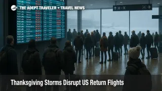
Thanksgiving storms are now set to disrupt US flights on the return travel weekend, with a second winter system lining up over the Central Plains, the Midwest, and the Great Lakes from November 29 through December 1, 2025. Travelers flying through Chicago, Illinois, Detroit, Michigan, Milwaukee, Wisconsin, Minneapolis, Minnesota, and other northern hubs should expect a new round of snow driven delays on top of already busy schedules and lingering staffing strain. Anyone with flexibility on dates or routes now has a short window to shift plans, add buffer, or choose hubs less exposed to snow and strong winds.
In practical terms, this Thanksgiving storms US flights pattern will shift the highest disruption risk from the outbound wave earlier in the week to the core return window, especially Saturday night and Sunday, which are already among the busiest travel days of the year.
Our earlier forecast, Thanksgiving Winter Storms Raise US Flight Delay Risks, focused on lake effect snow and a departing low that hit outbound travelers. Today, National Weather Service winter storm watches and warnings extend across Iowa, Minnesota, Wisconsin, Illinois, and Michigan, with many locations projected to see 6 to 10 inches of snow from Friday afternoon into Saturday night, and some Great Lakes belts likely to exceed a foot. Together with gusty winds along the East Coast and rain and mountain snow in the Pacific Northwest, that track puts both the core Midwest hubs and several coastal airports at risk of ground delays, reroutes, and missed connections over the full return weekend.
Storm Track And Weekend Timing
Weather models and NWS outlooks now show a second, more widespread winter storm organizing over the Central Plains late on Friday, November 28, then sliding east toward the Great Lakes and the interior Northeast through Sunday, November 30. Winter Storm Warnings from the Chicago forecast office cover much of northern Illinois and northwest Indiana from early Saturday through early Sunday, with forecasts calling for 6 to 10 inches of new snow in some of the metro Chicago corridor and heavier bands near the Wisconsin state line.
As this system strengthens, snow and blowing snow will likely complicate operations at Chicago O Hare International Airport (ORD), Chicago Midway International Airport (MDW), Detroit Metropolitan Wayne County Airport (DTW), and Milwaukee Mitchell International Airport (MKE), with spillover effects on Minneapolis Saint Paul International Airport (MSP) when the colder wraparound side of the storm passes through. By late Saturday and Sunday, the same low will help reinforce lake effect bands over upstate New York, northeast Ohio, northwest Pennsylvania, and parts of Michigan, where earlier lake effect bursts already produced one to two feet of snow in some belts.
For the Northeast, the bigger issue into Sunday and Monday is likely to be wind, low cloud ceilings, and periods of mixed precipitation rather than all day heavy snow. Boston Logan International Airport (BOS), John F Kennedy International Airport (JFK), LaGuardia Airport (LGA), Newark Liberty International Airport (EWR), and Philadelphia International Airport (PHL) are all prone to air traffic control, ATC, spacing programs in gusty or low cloud conditions, which can quickly turn on when upstream storms reshape the jet stream. The same pattern may also drive scattered flow controls at Washington Dulles International Airport (IAD) and Ronald Reagan Washington National Airport (DCA), even if local conditions look manageable from the terminal.
Airports And ATC Programs To Watch
Across the week so far, live trackers have already logged more than 6,600 delayed flights on one day and more than 1,000 flights canceled or delayed on another, as the first storm and early lake effect bands passed through major hubs. Early delay clusters have centered on Chicago O Hare and Dallas Fort Worth International Airport (DFW), with Chicago topping national delay tables as snow and wind arrived.
The Federal Aviation Administration, FAA, operations plans for November 27 and November 28 show a mix of ground stops, miles in trail spacing, and time based flow programs tied to low ceilings and gusty winds at New York City area airports, Boston, and several Western hubs, even before the main weekend storm arrives. When the new winter storm reaches the Midwest and Great Lakes, that same toolkit is likely to be applied to Chicago O Hare, Chicago Midway, Detroit, Milwaukee, and Minneapolis, and if snow bands align poorly with peak arrival banks, it will only take a few hours of reduced arrival rates to create multi hour knock on delays that propagate across the network.
Travelers outside the snow belt should not assume they are immune. West Coast gateways like San Francisco International Airport (SFO), Los Angeles International Airport (LAX), and Seattle Tacoma International Airport (SEA) often see indirect delays when aircraft and crews arrive late from the Midwest and Northeast, and when convective weather or marine layer clouds force ATC to slow arrival rates at the same time that the rest of the system is under strain.
Our separate daily report, Flight Delays And Airport Impacts: November 28, 2025, will continue to track which specific hubs face the heaviest flow control or ground stop risk each day.
Staffing Strain And Why Delays Ripple Faster
The current weather pattern is landing just after a 43 day US government shutdown that forced the FAA to order temporary schedule cuts of up to 10 percent at 40 major airports, in order to manage air traffic control staffing, then lifted those mandates only on November 17. Airlines used the shutdown to trim less profitable frequencies and tighten aircraft utilization, and although the emergency flight cuts have formally ended, several industry and government briefings still warn that operational disruptions are likely to persist while staffing pipelines catch up.
On the passenger side, AAA projects about 81.8 million Americans traveling at least 50 miles from home between Tuesday, November 25, and Monday, December 1, with more than 19 million traveling by air, which is enough to fill schedules to or near capacity even after the booking dip tied to the shutdown. That combination of near record demand and leaner staffing leaves airlines and ATC with less slack to absorb extended snow removal, de icing queues, or repeated runway direction changes.
In practice, this means that what might have been a one hour local delay at Chicago O Hare in a quieter season can now cascade into missed connections, crew time outs, and aircraft out of position problems that affect Boston Logan, New York City, Atlanta, Dallas, and the West Coast by later in the same day. Even when the shutdown specific flight caps are gone, the system still behaves as if it is operating close to its safe capacity ceiling.
For a deeper structural look at how winter operations strain airlines and ATC, see our evergreen explainer, How Winter Storms Disrupt US Flights.
Driving Versus Flying On The Return Weekend
For regional trips in the Midwest and Great Lakes, the second half of the weekend becomes a more complicated drive versus fly decision. Forecasts from AccuWeather and Newsweek show poor road conditions from Kansas and Nebraska east toward Illinois and Michigan from Friday night through Saturday night, with slick, snow covered highways and occasional whiteout conditions along key corridors.
On Saturday, snow rates and visibility may be bad enough that long freeway stretches parallel to air corridors, such as Chicago to Detroit or Chicago to Minneapolis, become marginal choices, especially for drivers who are not used to winter conditions. By Sunday afternoon, however, many main interstates should be plowed and treated, even if shoulders remain snow covered, while airport operations work through backlogs. For drives under about six hours that stay mostly on major interstates, shifting from a storm exposed regional flight to a daytime drive on Sunday or Monday can reduce disruption risk, provided travelers stay within the latest local advisories.
For longer distances or routes that cross multiple storm belts, flying remains the safer and more predictable option, as long as travelers build in generous buffers and avoid the tightest peak windows. FlightAware and other trackers continue to stress that early morning departures are less likely to be affected by knock on delays and offer more rebooking options if something goes wrong.
How To Protect Your Itinerary
With a clear signal that the main return risk now falls on Saturday night and Sunday, travelers still have a narrow chance to improve their odds. The most powerful step is to move tight Sunday returns to Friday afternoon, Saturday morning, or Monday, December 1, focusing on flights that either avoid the main snow belt or arrive earlier in the day. Many airlines are already publishing flexible travel policies or quietly allowing same fare date shifts for trips that touch high risk hubs, particularly for basic economy tickets that would normally be locked.
Next, travelers should rebuild connections through Chicago O Hare, Chicago Midway, Detroit, Milwaukee, and Minneapolis to leave at least three hours between flights, and avoid separate tickets through these hubs, where missed connections can require buying a completely new itinerary. Where routing tools offer a choice between a connection through a high risk hub such as Chicago and a more southerly hub such as Dallas Fort Worth or Hartsfield Jackson Atlanta International Airport (ATL), the extra flying time may be worth it to reduce weather exposure.
Finally, travelers should prepare for airport level friction even if their flights operate more or less on time. Plan for longer lines at security and concessions, bring backup chargers and snacks, and monitor airline apps plus FAA tools like the National Airspace System Status page and ATCSCC advisories for live information about ground stops and flow restrictions. Our daily US Airport Delays coverage will remain the best way to see which hubs are currently under the heaviest strain.
Background: Why Thanksgiving Return Flights Are Vulnerable
Thanksgiving concentrates travel into a narrow window, from the outbound peak on the Tuesday and Wednesday before the holiday through the sharp return peak on the Sunday after. Airlines for America estimates that US carriers will move more than 31 million passengers between November 21 and December 1 on scheduled flights, and the FAA projects more than 360,000 flights across the same period, making it the busiest Thanksgiving air travel period in 15 years.
In a normal year, that density of flying would be challenging but manageable, because airlines would maintain more spare aircraft and crew, and the FAA would not have needed to cut schedules preemptively. This year, the long shutdown and emergency ATC orders have left schedules flatter but also more brittle, with fewer marginal flights left in the system to absorb rebookings when storms appear.
Taken together, the storm outlook and structural constraints mean that this Thanksgiving return weekend will require more active planning than usual. Travelers who treat the forecast as a cue to adjust dates, hubs, and connection buffers now will likely have a smoother trip home than those who wait to react at the airport.
Sources
- US Midwest And North Brace For Storm As Nearly 82m People Travel For Holidays
- Record Thanksgiving Travel As Snowstorms Cause 800+ Flight Delays
- Area Forecast Discussion, NWS Chicago
- Point Forecast, Eastern Iowa And Western Illinois
- ATCSCC Operations Plan Advisories, November 27-28, 2025
- AAA Thanksgiving 2025 Travel Forecast
- FAA Expects Busiest Thanksgiving Travel Period In 15 Years
- Government Shutdown Dampens Record Setting Thanksgiving Air Travel Forecast
- US Airlines Grapple With Shutdown Fallout As Thanksgiving Nears
- Thanksgiving Travel Warning Issued As Major Snowstorm Looms
- ADS B Network News, November 2025, FlightAware