Storm Ezra US Flight Delays at Major Hubs Dec 30, 2025
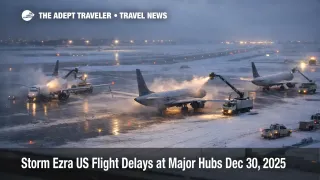
Storm Ezra is keeping the U.S. flight network unstable across the Great Lakes and the Northeast, with weather and air traffic flow limits stacking on top of already mispositioned aircraft and crews. Travelers connecting through the Boston and New York corridor, plus snow exposed Great Lakes hubs, are seeing higher odds of late changes, including rolling delays, short notice cancellations, and missed connections. Your next move is to check whether your hub is under an FAA program, then decide early whether you are rebooking, rerouting, or adding an overnight buffer.
The FAA's daily outlook calls out low clouds in General Edward Lawrence Logan International Airport (BOS), wind in the New York airports, and snow in Detroit Metropolitan Wayne County Airport (DTW) and Chicago O Hare International Airport (ORD), a combination that tends to cap arrival rates and back up hub banks. FAA planning guidance for the afternoon also flags possible ground stop or delay programs for BOS, LaGuardia Airport (LGA), John F Kennedy International Airport (JFK), Newark Liberty International Airport (EWR), Washington Dulles International Airport (IAD), and Philadelphia International Airport (PHL), while listing active terminal constraints tied to low ceilings, wind, and snow, including Chicago Midway International Airport (MDW).
Who Is Affected
Travelers most exposed today are anyone connecting through BOS, the New York area airports, PHL, or IAD during afternoon and evening banks, because even modest rate cuts can cascade into long rebooking queues when flights are full for New Year week. Great Lakes itineraries that touch DTW, ORD, or MDW are also high risk, because snow and wind disruptions tend to break aircraft rotations, then push cancellations into later flights when crews time out.
If you are chaining segments, the second order risk is bigger than the first delay. Late inbound aircraft can miss their slot into constrained airspace, crews can exceed legal duty limits, and the cancellation that hits you may be the third or fourth downstream leg of an aircraft that never arrived on time. Reuters reported thousands of delays and significant cancellations as the storm extended into a third day, alongside FAA ground stops at multiple airports and airline waiver activity. Power outages and hazardous driving amplify the disruption by slowing airport access, hotel rebooking, and ground transfers, which the Associated Press also highlighted as the storm's impacts spread across the Great Lakes and the Northeast.
For continuity with the earlier setup and how this pattern has evolved across the holiday week, reference Devin, Ezra Great Lakes Flights Disruptions Dec 28-30 and Flight Delays and Airport Impacts: December 29, 2025. For deeper context on why the system can stay fragile even after conditions improve at one airport, see U.S. Air Traffic Control Privatization: Reality Check.
What Travelers Should Do
First, treat today as a buffer building day, not a best case day. If you have a connection in the Northeast corridor or the Great Lakes, shift to an earlier departure if seats exist, because later banks absorb the day's backlog, and become cancellation magnets when programs go active. Use the FAA airport status pages and the FAA planning advisory language, because a ground stop or a ground delay program is the clearest public signal that the system is metering arrivals and that your delay may grow.
Second, set a hard decision threshold for rebooking versus waiting. A practical cutoff is when your first leg delay erases your planned connection buffer, or when your hub moves from "possible" to "active" program language in FAA guidance, because recovery often slows once arrivals are capped. If your carrier offers a waiver, use it early, because the best alternates disappear first, and fare class availability can vanish even when flights show seats. Delta's advisory language, for example, spells out rebooking options through December 30, 2025 for certain impacted itineraries.
Third, monitor the next 24 to 72 hours like a sequence, not a single flight. Watch for lake effect persistence and snow squall risk into New Year's Eve across the Great Lakes and the Northeast, which the National Weather Service has been emphasizing in its national hazards messaging. Recheck FAA planning updates before you leave for the airport, because programs can appear, expand, or end quickly as winds, ceilings, and runway configurations change, especially around BOS and the New York complex.
Background
Storm driven irregular operations propagate through the travel system in layers. The first order hit is local capacity loss, like low ceilings in Boston or wind limited arrival rates in the New York and Mid Atlantic corridor, combined with snow impacts in Great Lakes hubs that slow taxi, deicing, and runway throughput. The second order ripple shows up as mispositioned aircraft and crews, where a late arrival into a hub breaks the next departure, then pushes cancellations into later banks when duty time limits are reached, even if weather is improving at the origin. The third order effects spread into hotels, rental cars, and ground transfers, because stranded travelers compress inventory near terminals, while power outages and hazardous roads make even short repositioning trips harder to execute, raising overnight costs and reducing reliable alternates.
Sources
- FAA Daily Air Traffic Report
- Current Operations Plan Advisory (ATCSCC ADVZY 068 DCC 12/30/2025)
- Northeast Winter Weather, Delta Air Lines Travel Advisory
- Winter Storm Ezra snarls US travel as meteorologists warn of bomb cyclone, Reuters
- Arctic blast brings snow and wind to the Great Lakes and Northeast, AP
- National Weather Service Hazards Headline