Flight Delays and Airport Impacts: December 31, 2025
US flight delays December 31 are being driven by two familiar winter constraints, wind in the Northeast corridor and snow risk in the Great Lakes and Chicago airspace. The FAA's daily outlook specifically flagged wind as a potential limiter for General Edward Lawrence Logan International Airport (BOS), the New York airports, Philadelphia International Airport (PHL), and the Washington, DC, area, with snow risk called out for Detroit Metropolitan Wayne County Airport (DTW) and the Chicago airports.
Operationally, the day started with program risk around the New York complex, including an FAA Command Center plan that showed a Ground Delay Program active at John F. Kennedy International Airport (JFK) earlier in the day and warned of potential additional initiatives for JFK and Newark International Airport (EWR), plus Boston and Philadelphia if ceilings and wind reduced arrival rates. Separately, the FAA published a Denver International Airport (DEN) scheduling delay advisory window tied to compacted demand, a reminder that weather is not the only constraint that can produce controlled flows.
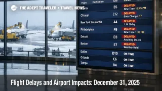
At the airport level, the midday snapshot looked deceptively calm across several of the headline hubs. FAA status pages were generally showing minor baseline delays for BOS, JFK, La Guardia Airport (LGA), EWR, and Washington Dulles International Airport (IAD), and On Time conditions at PHL, DTW, Chicago O'Hare International Airport (ORD), and Chicago Midway International Airport (MDW). That does not eliminate disruption risk, because winter days often fail in the afternoon and evening banks when arrival rates tighten and late inbound aircraft compress the schedule.
Who Is Affected
Travelers most exposed today are anyone whose itinerary touches the Northeast hub corridor, especially JFK, LGA, EWR, BOS, PHL, or IAD during peak connection banks. When wind and ceiling constraints force lower arrival acceptance rates, the first order effect is slower arrivals and longer gate occupancy, and the second order effect is missed connections as the same aircraft cannot turn on time for the next leg.
Great Lakes and Midwest travelers also sit in the higher risk bucket, even when the airport status banner reads On Time. Snow and winter surface operations, including runway treatment and braking action variability, can slow taxi flows, increase deicing cycles, and create missed slot times that push delays into the late day wave. That disruption then propagates outward, because ORD and DTW feed hundreds of downline spokes, and late hubs can strand crews away from their next day starts.
Finally, travelers on Florida and Gulf routings should not ignore airspace management tools. FAA Command Center reroute and flow constrained area advisories can impose structured routing and metering that creates departure holds upstream, even if your departure airport weather is fine, and even if your destination is reporting only minor baseline delays.
What Travelers Should Do
Start with immediate actions and buffers. Before leaving for the airport, check the FAA airport status pages for your departure and connection points, then assume a gate hold is still possible if the network is metering arrivals at your destination. If you have a same day connection under 60 minutes in the Northeast corridor, treat it as fragile today, because a small rate cut can erase the buffer quickly.
Use clear decision thresholds for rebooking versus waiting. If you are pushed onto the last flight of the day, if your connection drops below 45 minutes after a delay posts, or if the FAA planning posture shifts from "manageable with miles in trail" to an active airport program, rebook early while seats still exist. Waiting only makes sense when you have multiple protected options on the same ticket later in the day and your arrival time is not tied to a hard commitment.
Over the next 24 to 72 hours, monitor whether today's constraints repeat into the first morning bank on January 1, 2026, because repeated rate cuts are what turn normal delays into reaccommodation backlogs. Watch for updates to FAA operations plan advisories, plus reroute and flow constrained area postings, since those often explain why your aircraft is held at the gate even when you do not see storms out the window.
How It Works
The FAA's Air Traffic Control System Command Center manages national demand when airport or airspace capacity drops, using tools such as ground delay programs, ground stops, scheduling delays, reroutes, and flow constrained areas. The traveler visible effect is that delay time is often moved to the ground through assigned departure holds, which reduces airborne holding and protects arrival rates at the constrained airport.
Disruption then propagates through the travel system in layers. First order impacts appear at the constrained airport, arrivals slow, gates stay occupied longer, and departures inherit late turns. Second order ripples spread through connections and crew flow, because aircraft rotations and duty limits mean one late hub arrival can degrade later departures in multiple cities. A third layer shows up off airport property, because missed last flights collide with limited late night ground transport, rental car counter hours, and hotel inventory near major hubs.
For additional context on how recent winter instability has been playing out across the network, see Flight Delays and Airport Impacts: December 30, 2025 and Storm Ezra US Flight Delays at Major Hubs Dec 30, 2025.
Sources
- FAA Daily Air Traffic Report
- ATCSCC Current Operations Plan Advisory 002
- ATCSCC Advisory 004 DEN Scheduling Delays
- ATCSCC Current Reroutes
- FAA ATCSCC BOS Real Time Status
- FAA ATCSCC JFK Real Time Status
- FAA ATCSCC EWR Real Time Status
- FAA Airport Status PHL
- FAA Airport Status DTW
- FAA Airport Status ORD
- FAA Airport Status MDW