Flight Delays and Airport Impacts: January 14, 2026
The FAA is flagging a multi region weather pattern that can slow major hub operations today, with snow and strong winds centered on Detroit Metropolitan Wayne County Airport (DTW) and the Chicago hubs, gusty winds in the New York area and North Texas, plus low clouds around Seattle Tacoma International Airport (SEA) and San Francisco International Airport (SFO). Travelers connecting through these hubs, or positioning to long haul departures later in the day, are the most exposed to knock on delays and misconnects. The practical move is to protect connection time now, monitor FAA and airline updates through the peak banks, and be ready to switch routings early if your itinerary is tight.
The change for travelers is straightforward, U.S. flight delays January 14 risk rises because weather can force arrival rate cuts at hubs that anchor national connection banks, and FAA traffic management can then hold flights at their origin to protect the system.
FAA planning notes point to snow and wind constraints at DTW and Chicago O'Hare International Airport (ORD), wind constraints tied to the New York area airspace complex, and low ceilings or visibility constraints at SEA and SFO, with possible ground stop or delay programs for Seattle and San Francisco after 1600Z. Even when airport boards show "on time" early, throughput limits tend to bite hardest once the day's largest banks build, and that is when gate holds, missed connections, and late aircraft turns start to propagate.
Who Is Affected
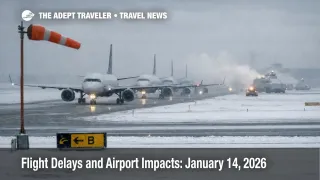
Travelers departing from, arriving into, or connecting through DTW face snow and wind sensitivity that can show up as slower deicing, longer taxi times, and reduced acceptance rates when conditions deteriorate. The first order hit is at the source airport, where departures slip and inbound aircraft arrive late, which then pushes delays into subsequent legs that were built on tight turns.
Chicago Midway International Airport (MDW) and ORD are the day's other major winter exposure points. Chicago's hub structure matters because it acts as a mixing bowl for connecting flows across the Midwest, West, and East, so a slowdown there does not stay local. FAA status pages show ORD under a snow and ice traffic management program with minor arrival delays reported, which is exactly the kind of "small" constraint that can still break short connections once demand peaks.
In the Northeast, gusty winds can compress arrival and departure rates at Newark Liberty International Airport (EWR), John F. Kennedy International Airport (JFK), and LaGuardia Airport (LGA), and the important detail is that the constraint is often the airspace and runway configuration, not just a single airport's surface weather. When the New York area complex slows, the impact often appears first as delays at your departure airport, because flights are held on the ground to avoid airborne holding into the constrained arrival stream.
In North Texas, gusty winds can create arrival rate cuts that ripple across Dallas Love Field (DAL) and Dallas Fort Worth International Airport (DFW) schedules, especially in late afternoon banks. Meanwhile, the Pacific Northwest and Northern California risk is a ceiling and visibility story. Low clouds in Seattle and low visibility in San Francisco can trigger spacing increases and flow programs that hold inbound flights before they depart, which then spills into missed hotel check in times, late rental car pickups, and broken same day connections.
If you want broader context for why hub slowdowns can ripple nationwide even when the weather looks regional, see U.S. Air Traffic Control Privatization: Reality Check. For continuity with yesterday's pattern and how these programs tend to "arrive late" in the day, see Flight Delays and Airport Impacts: January 13, 2026.
What Travelers Should Do
If you are flying through DTW, Chicago, the New York area, DFW, SEA, or SFO today, start by checking your airline app for waiver language, then look up your inbound aircraft and whether the first leg is already sliding. Add buffer where it actually absorbs shocks, earlier departures, longer connections, and avoiding last flights of the day, because recovery margin shrinks as banks stack up.
Use decision thresholds instead of hope. If your connection is under 90 minutes in the New York area complex, or under 75 minutes through DTW or Chicago on a snow and wind day, treat it as breakable once traffic management starts, and switch proactively if you can move to an earlier itinerary or a routing that avoids the most exposed hub. If you have a large buffer and multiple later flights exist on the same ticket, it can be reasonable to wait, but only if your downstream commitment can tolerate a late arrival.
Over the next 24 to 72 hours, monitor whether today's "possible" programs turn into active ground stops or ground delay programs for Seattle and San Francisco, and whether Chicago's runway treatment needs force a lower runway configuration that triggers more aggressive metering. Also keep an eye on how runway, ramp, and taxiway constraints can magnify peak bank delays even when weather improves, which is why FAA Runway Closures at US Airports Raise Delay Risk remains relevant as an overlay on weather days.
How It Works
The FAA's daily report is a planning lens, it highlights where weather can reduce throughput, and where travelers should expect the system to protect itself with metering. The first order effect is simple capacity math. Snow and wind slow deicing and runway operations, gusty winds force less efficient runway configurations and larger spacing, and low ceilings or visibility demand more conservative separation. When arrival acceptance rates fall, the FAA can respond by holding flights at their origin gates or by delaying departures into the constrained destination, because it is safer and more controllable than letting airborne holding build.
The second order ripple is network propagation. Once arrivals bunch into fewer windows, aircraft turns run late, crews lose duty time margin, and the same aircraft that was supposed to operate your next segment is now arriving behind schedule. That turns a local slowdown into a national one as rotations break, substitution aircraft get reassigned, and rebooking demand concentrates onto fewer remaining flights. This is why travelers often experience the disruption at a completely different airport than the one that started the constraint.
A third layer is the quiet constraint stack that sits behind weather. FAA planning for January 14 lists runway, ramp, and taxiway limitations at several airports, plus longer duration construction items such as a taxiway closure at ORD, a shortened runway at DTW, and a taxiway closure at DFW. These do not always dominate the day, but they reduce the system's ability to "make it back" during peak banks, increasing the chance that a manageable delay becomes a missed connection or an overnight.
Sources
- FAA Daily Air Traffic Report
- Current Operations Plan Advisory
- Chicago OHare International Airport (ORD) Real-time Status
- Detroit Metropolitan Wayne County Airport (DTW) Real-time Status
- John F Kennedy International Airport (JFK) Real-time Status
- La Guardia Airport (LGA) Real-time Status
- Dallas Fort Worth International Airport (DFW) Real-time Status
- San Francisco International Airport (SFO) Real-time Status
- Seattle Tacoma International Airport (SEA) Status
- Chicago Midway International Airport (MDW) Status