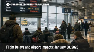
Flight Delays and Airport Impacts: January 30, 2026
The FAA's national planning outlook for January 30 flagged snow and gusty winds as the main reasons flights could slow at Chicago O'Hare International Airport (ORD) and Chicago Midway Airport (MDW), with high winds also in the mix for several Northeast hubs. Travelers connecting through General Edward Lawrence Logan International Airport (BOS), Newark Liberty International Airport (EWR), John F Kennedy International Airport (JFK), LaGuardia Airport (LGA), Philadelphia International Airport (PHL), Baltimore Washington International Thurgood Marshall Airport (BWI), Ronald Reagan Washington National Airport (DCA), and Washington Dulles International Airport (IAD) are the most exposed to knock on delays. The practical move is to protect connection time early and be ready to reroute, because flow programs can start mid day and the delay often appears first at your departure airport.
The U.S. Flight Delays January 30, 2026 setup is a familiar winter pattern, localized weather constraints at a few dense hubs can force the system to meter traffic to keep arrival rates safe. The FAA Daily Air Traffic Report explicitly called out snow and winds in Chicago, high winds across Boston, New York, Philadelphia, and the Washington area, plus low clouds forecast at Seattle-Tacoma International Airport (SEA).
Who Is Affected
Travelers who touch Chicago and the Northeast corridor are first in line because those hubs sit on high frequency banks where a small reduction in acceptance rate quickly becomes visible as gate holds and missed connections. FAA command center planning notes for January 30 also pointed to possible traffic management initiatives later in the day, including the potential for programs at Chicago's major airports after the late morning window, a possible program for LaGuardia in the afternoon, and continued planning attention on Washington National. In plain terms, once the system starts metering arrivals into a hub, your departure can be held at the gate at your origin even if your origin weather is calm, because the destination cannot safely accept the full stream.
Washington area itineraries have an extra operational wrinkle. A late evening FAA airport status snapshot for Washington National showed a traffic management program tied to snow and ice that was delaying some inbound flights by an average of about 2 hours, which is enough to push crews and aircraft off sequence for later legs and to amplify misconnect risk into the evening bank. Even if conditions improve at the field, that earlier metering can linger as a network aftershock as aircraft and crews reposition.
West Coast travelers are not the main story, but they can still feel the ripple. The FAA outlook highlighted low clouds at Seattle, and planning notes flagged low ceilings there as a potential constraint. When a hub like Seattle runs more conservatively in low visibility, arrival spacing expands, gate turns slip, and that lost slack can propagate into transcontinental rotations later in the day.
For context on how storm driven disruption can keep seat inventory tight even after the weather footprint shifts, Storm Fern American Airlines Recovery Strains Crews is a useful companion read. If your trip crosses the East Coast weekend window, Winter Storm Gianna East Coast Flight Waivers Jan 30 Feb 2 explains why waivers and early date shifts can be the difference between a same day reroute and an overnight.
What Travelers Should Do
Start with immediate actions and buffers. Check your flight status before you leave for the airport, then check again at the curb, because FAA initiatives can activate quickly when winds peak or snow removal reduces runway availability. If your itinerary touches Chicago, New York, Philadelphia, or the Washington area, assume taxi out and gate holds can stretch, keep essentials in your personal item, and avoid planning a single tight ground transfer on arrival.
Use decision thresholds for rebooking versus waiting. If a delay compresses a domestic connection under about 90 minutes, or a domestic to international connection under about 2 hours, treat that as a practical trigger to look for earlier departures, nonstop options, or routings that avoid the most constrained hub. If you are traveling on separate tickets, move faster, because the first carrier is not obligated to protect your onward segment, and weather metering can erase your cushion without a single dramatic cancellation event.
Over the next 24 to 72 hours, monitor three layers rather than one. Watch the FAA Daily Air Traffic Report for whether the same hubs stay highlighted, watch FAA command center planning advisories for whether programs are anticipated for the afternoon and evening banks, and watch your airline for waiver expansions that can convert an expensive same day change into a no fee rebooking. If you want a baseline for how quickly "forecast risk" can become "real delay minutes" at Northeast hubs, compare conditions with Flight Delays and Airport Impacts: January 29, 2026.
How It Works
The FAA's air traffic system is built around matching demand to what each airport and its surrounding airspace can safely handle in a given hour. Snow, deicing, and runway treatment reduce runway throughput and extend turnaround times at the source, while high winds can force runway configuration changes and increase required spacing on approach and departure. Low ceilings and reduced visibility can also require more conservative arrival rates. Those first order constraints are why a hub can look normal at mid day, then slip quickly when a peak bank collides with tightening conditions.
Traffic management tools are designed to prevent unsafe airborne congestion by controlling the flow earlier in the chain. Instead of letting aircraft stack overhead, the system may delay departures at origin airports, assign controlled departure times, or slow inbound streams, which is why your delay can start at the gate far from the weather. The FAA command center's operations planning advisories are an early signal of where that metering may be used, and the airport status pages show when destination specific delay programs are affecting inbound flows.
The second order ripple is what travelers feel most. Once aircraft arrive late, gate turns slip, crews lose duty time margin, and the same airplane you are waiting on for a later leg is now arriving behind schedule. That can create late day cancellations even after conditions start improving, because airlines protect the next morning's network by trimming flights that would otherwise strand crews out of position overnight. Those aviation ripples spill into ground transportation and hotels as well, because irregular arrival waves shift rideshare peaks, and airport area rooms can tighten when misconnects turn into unplanned nights.
Sources
- FAA Daily Air Traffic Report
- ATCSCC Current Operations Plan Advisory
- FAA Airport Status, Chicago OHare International Airport (ORD)
- FAA Airport Status, Chicago Midway Airport (MDW)
- FAA Airport Status, General Edward Lawrence Logan International Airport (BOS)
- FAA Airport Status, Newark International Airport (EWR)
- FAA Airport Status, Philadelphia International Airport (PHL)
- FAA Airport Status, Ronald Reagan Washington National Airport (DCA)
- FAA Airport Status, Seattle-Tacoma International Airport (SEA)
- FAA Airport Status, Baltimore/Washington International Thurgood Marshall Airport (BWI)